IMAGES TAKEN NEAR TO
St. Donats Close, CWMBRAN, NP44 8SB
Introduction
This page details the photographs taken nearby to St. Donats Close, NP44 8SB by members of the Geograph project.
The Geograph project started in 2005 with the aim of publishing, organising and preserving representative images for every square kilometre of Great Britain, Ireland and the Isle of Man.

There are currently over 7.5m images from over14,400 individuals and you can help contribute to the project by visiting https://www.geograph.org.uk
Image Map
Images are licensed for reuse under creativecommons.org/licenses/by-sa/2.0
Notes
- Clicking on the map will re-center to the selected point.
- The higher the marker number, the further away the image location is from the centre of the postcode.
Image Listing (156 Images Found)
Images are licensed for reuse under creativecommons.org/licenses/by-sa/2.0
Image
Details
Distance
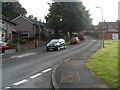
1
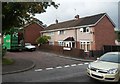
St Donats Close, Cwmbran
St Donats Close is one of several cul-de-sacs on the south side of Liswerry Drive.
Image: © Jaggery
Taken: 22 Aug 2012
0.01 miles
2
Down Liswerry Drive, Llanyravon, Cwmbran
Liswerry Drive viewed from the corner of Ceredig Place.
Image: © Jaggery
Taken: 12 Apr 2017
0.02 miles
3
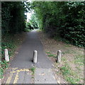
Path beyond the NE end of Mill Lane, Cwmbran
Concrete posts prevent cars or lorries using the path.
The location is near the former Commodore Hotel. http://www.geograph.org.uk/photo/3628091
Image: © Jaggery
Taken: 30 Aug 2013
0.02 miles
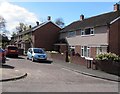
4
Ceredig Place, Llanyravon, Cwmbran
Ceredig Place is a cul-de-sac on the south side of Liswerry Drive.
Image: © Jaggery
Taken: 12 Apr 2017
0.03 miles
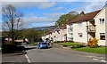
5
Liswerry Drive, Cwmbran
Viewed from the corner of Beaumaris Drive.
Image: © Jaggery
Taken: 22 Aug 2012
0.04 miles
6
Rhodri Place, Llanyravon, Cwmbran
Rhodri Place is a cul-de-sac on the south side of Liswerry Drive.
Image: © Jaggery
Taken: 12 Apr 2017
0.05 miles
7
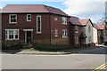
Houses built in 2016, Mill Lane, Llanyravon, Cwmbran
The year 2016 is on the tablet on the right side of a drainpipe, viewed in April 2017.
The houses are on the site formerly occupied by the Commodore Hotel seen here http://www.geograph.org.uk/photo/3628091 in August 2013.
Image: © Jaggery
Taken: 12 Apr 2017
0.05 miles
8
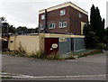
Boarded-up former Willows restaurant and cocktail bar, Cwmbran
This was part of the Commodore Hotel http://www.geograph.org.uk/photo/3628091 which has closed down.
Image: © Jaggery
Taken: 30 Aug 2013
0.05 miles
9
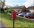
Queen Elizabeth II postbox on a Llanyravon corner, Cwmbran
On the corner of Liswerry Drive and Rhodri Place.
Image: © Jaggery
Taken: 12 Apr 2017
0.06 miles
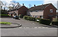
10
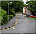
Mill Lane, Llanyravon, Cwmbran
Viewed from the corner of Beaumaris Drive. Double yellow lines
on both sides of Mill Lane indicate no parking at any time.
Image: © Jaggery
Taken: 8 Sep 2017
0.06 miles