IMAGES TAKEN NEAR TO
Hawarden Green, CWMBRAN, NP44 8RU
Introduction
This page details the photographs taken nearby to Hawarden Green, NP44 8RU by members of the Geograph project.
The Geograph project started in 2005 with the aim of publishing, organising and preserving representative images for every square kilometre of Great Britain, Ireland and the Isle of Man.

There are currently over 7.5m images from over14,400 individuals and you can help contribute to the project by visiting https://www.geograph.org.uk
Image Map
Images are licensed for reuse under creativecommons.org/licenses/by-sa/2.0
Notes
- Clicking on the map will re-center to the selected point.
- The higher the marker number, the further away the image location is from the centre of the postcode.
Image Listing (134 Images Found)
Images are licensed for reuse under creativecommons.org/licenses/by-sa/2.0
Image
Details
Distance
1
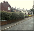
Hawarden Green, Cwmbran
Hawarden Green is a cul-de-sac on the east side of Liswerry Drive.
Image: © Jaggery
Taken: 22 Aug 2012
0.01 miles
2
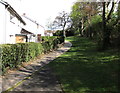
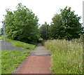
Path between Hawarden Green houses and Turnpike Road, Llanyravon, Cwmbran
The trees on the right are at the edge of the A4042 Turnpike Road.
Image: © Jaggery
Taken: 12 Apr 2017
0.02 miles
3
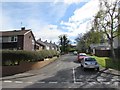
Hawarden Green, Llanyravon, Cwmbran
Cul-de-sac on the east side of Liswerry Drive.
Image: © Jaggery
Taken: 12 Apr 2017
0.02 miles
4
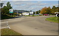
Turnpike Road entrance to Cwmbran
The edge of the A4042 roundabout at the entrance to Cwmbran along Turnpike Road, which begins adjacent to the welcome to Cwmbran sign. Cwmbran is twinned with Bruchsal (Germany).
Image: © Jaggery
Taken: 8 Oct 2009
0.04 miles
5
Footpath to Hawarden Green, Cwmbran
Viewed from the southern end of Turnpike Road, out of shot on the left.
Image: © Jaggery
Taken: 27 Jun 2012
0.04 miles
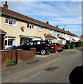
6
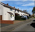
Row of houses, Liswerry Drive, Llanyravon, Cwmbran
On the west side of Liswerry Drive between Liswerry Close and Dunraven Road.
Image: © Jaggery
Taken: 12 Apr 2017
0.04 miles
7
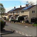
Rooftop solar panels, Liswerry Drive, Llanyravon, Cwmbran
Viewed from the corner of Pembroke Place.
Image: © Jaggery
Taken: 12 Apr 2017
0.05 miles
8
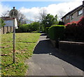
No Cycling sign facing Liswerry Drive, Llanyravon, Cwmbran
Alongside a footpath ascending towards Hawarden Green houses at the edge of the A4042 Turnpike Road.
Image: © Jaggery
Taken: 12 Apr 2017
0.05 miles
9
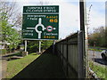
Directions sign on the approach to Turnpike Roundabout, Cwmbran
Facing northbound traffic on the A4042 Turnpike Road.
Turnpike Roundabout is Cylchfan Dyrpeg in Welsh.
The path on the left leads to Hawarden Green and Liswerry Drive.
Image: © Jaggery
Taken: 12 Apr 2017
0.06 miles
10
Long row of houses, Liswerry Drive, Llanyravon, Cwmbran
Viewed from the corner of Stowe Path.
Image: © Jaggery
Taken: 12 Apr 2017
0.06 miles