IMAGES TAKEN NEAR TO
Cilgerran Court, CWMBRAN, NP44 8RL
Introduction
This page details the photographs taken nearby to Cilgerran Court, NP44 8RL by members of the Geograph project.
The Geograph project started in 2005 with the aim of publishing, organising and preserving representative images for every square kilometre of Great Britain, Ireland and the Isle of Man.

There are currently over 7.5m images from over14,400 individuals and you can help contribute to the project by visiting https://www.geograph.org.uk
Image Map
Images are licensed for reuse under creativecommons.org/licenses/by-sa/2.0
Notes
- Clicking on the map will re-center to the selected point.
- The higher the marker number, the further away the image location is from the centre of the postcode.
Image Listing (125 Images Found)
Images are licensed for reuse under creativecommons.org/licenses/by-sa/2.0
Image
Details
Distance
1
Liswerry Drive, Llanyrafon, Cwmbran
This is the north end of Liswerry Drive, close to the Methodist church. http://www.geograph.org.uk/photo/1704014 These houses are on the east side of the road.
Image: © Jaggery
Taken: 11 Feb 2010
0.01 miles
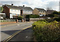
2
Narberth Crescent, Llanyravon, Cwmbran
Cul-de-sac on the west side of Liswerry Drive.
The sign shows that Narberth Crescent leads to Cilgerran Court and Rumney Walk.
Image: © Jaggery
Taken: 12 Apr 2017
0.03 miles
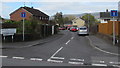
3
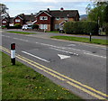
Liswerry Drive bus stop, Llanyravon, Cwmbran
This stop near the Narberth Crescent junction is on bus route 3 to Cwmbran bus station.
In April 2017 the route is operated by Anslow Bus & Coach Travel. http://www.geograph.org.uk/photo/5340188
Image: © Jaggery
Taken: 12 Apr 2017
0.03 miles
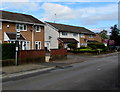
4
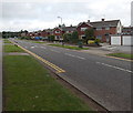
Four semis on a Llanyravon corner, Cwmbran
Semi-detached houses on the corner of Llanyravon Way and Liswerry Drive in the Llanyravon area of Cwmbran. A postbox http://www.geograph.org.uk/photo/5349628 is in a brick pillar on the right.
Image: © Jaggery
Taken: 12 Apr 2017
0.04 miles
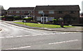
5
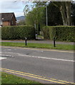
Llanyravon Way speed bumps, Llanyravon, Cwmbran
The bumps across Llanyravon Way are in a 20mph maximum speed zone near a primary school.
Image: © Jaggery
Taken: 12 Apr 2017
0.05 miles
6
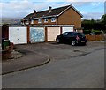
Four lockup garages, Liswerry Drive, Llanyravon, Cwmbran
Near the northern end of Liswerry Drive and the Llanyravon Way junction.
Image: © Jaggery
Taken: 12 Apr 2017
0.05 miles
7
NE end of Llanyrafon Way, Cwmbran
Looking towards Turnpike Road and Croesyceiliog.
Image: © Jaggery
Taken: 30 Aug 2013
0.05 miles
8
Toward a path beyond a gap in the hedge, Llanyravon, Cwmbran
Viewed across Llanyravon Way. The path http://www.geograph.org.uk/photo/5346887 is Dorstone Walk.
Image: © Jaggery
Taken: 12 Apr 2017
0.05 miles
9
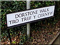
Bilingual name sign facing Llanyravon Way, Llanyravon, Cwmbran
Located in a gap in a hedge here, http://www.geograph.org.uk/photo/5346896 the sign shows that Dorstone Walk is Tro Tref Y Cernyw in Welsh.
Image: © Jaggery
Taken: 12 Apr 2017
0.05 miles
10
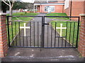
Llanyrafon Church Gates
The gates of Llanyrafon Methodist Church.
Image: © David Roberts
Taken: 19 Feb 2009
0.05 miles