IMAGES TAKEN NEAR TO
Tram Lane, CWMBRAN, NP44 8AF
Introduction
This page details the photographs taken nearby to Tram Lane, NP44 8AF by members of the Geograph project.
The Geograph project started in 2005 with the aim of publishing, organising and preserving representative images for every square kilometre of Great Britain, Ireland and the Isle of Man.

There are currently over 7.5m images from over14,400 individuals and you can help contribute to the project by visiting https://www.geograph.org.uk
Image Map
Images are licensed for reuse under creativecommons.org/licenses/by-sa/2.0
Notes
- Clicking on the map will re-center to the selected point.
- The higher the marker number, the further away the image location is from the centre of the postcode.
Image Listing (66 Images Found)
Images are licensed for reuse under creativecommons.org/licenses/by-sa/2.0
Image
Details
Distance
1
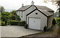
Oak Cottage, Llanfrechfa
Viewed from Caerleon Road.
Image: © Jaggery
Taken: 15 Oct 2009
0.03 miles
2
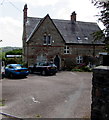
Grade II Listed Vicarage, Llanfrechfa, Torfaen
Cadw records that this polychrome vicarage of 1856 was influenced by John Ruskin's "Stones of Venice" of 1851-1853. Grade II Listed in 2003 as an excellent example of a High Victorian Gothic vicarage.
Image: © Jaggery
Taken: 22 May 2020
0.07 miles
3
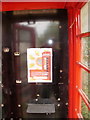
Deceptive phonebox, Llanfrechfa
A notice on the outside of the phonebox http://www.geograph.org.uk/photo/1634455 states "no coins accepted here". A notice inside the phonebox explains -
"BT no longer owns this kiosk. The telephone equipment has been removed and the kiosk is owned and maintained by the local authorities".
In this case, the local authority is Ponthir Community Council.
Image: © Jaggery
Taken: 15 Oct 2009
0.07 miles
4
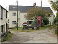
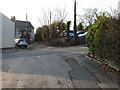
Tram Lane, Llanfrechfa
Tram Lane, on the left, heads away from Caerleon Road.
Trams (or tram roads or tram lanes) were roads with wooden, stone, or metal wheel-tracks, originally in or from a coalmine, later used more widely. Once common in south-east Wales, nowadays the street name is often the only remaining evidence of a tram. Another former tram road is nearby. http://www.geograph.org.uk/photo/1812875
The phone box on the right has a notice which states "no coins accepted here". The reason is ... http://www.geograph.org.uk/photo/1634459
Image: © Jaggery
Taken: 15 Oct 2009
0.07 miles
5
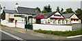
The Raj Gate, Llanfrechfa
Indian restaurant and takeaway. There is an adjoining car park, and a bus stop (and small postbox) adjacent to the premises.
UPDATE January 2013
The Gate at Llanfrechfa http://www.geograph.org.uk/photo/3280455 village pub & restaurant opened here in October 2012.
Image: © Jaggery
Taken: 15 Oct 2009
0.07 miles
6

Church Road, Llanfrechfa
Church Road heads away from Caerleon Road.
Image: © Jaggery
Taken: 15 Oct 2009
0.07 miles
7
Caerleon Road, Llanfrechfa
Looking southeastwards along Caerleon Road as it approaches the older part of Llanfrechfa. The turning for Church Road is on the left, just past the tree.
Image: © Jaggery
Taken: 15 Oct 2009
0.07 miles
8
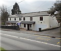
The Old Post Office Cottage, Llanfrechfa
The two semi-detached houses are located opposite The Gate at Llanfrechfa http://www.geograph.org.uk/photo/3280455 car park.
The Old Post Office Cottage is on the right.
Image: © Jaggery
Taken: 3 Jan 2013
0.07 miles
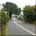
10
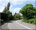
Bend in Caerleon Road, Llanfrechfa, Torfaen
The B4236 Caerleon Road is the main road through the village.
The double white lines indicate no overtaking.
Ahead for Cwmbran. Behind the camera for Ponthir and Caerleon.
Image: © Jaggery
Taken: 22 May 2020
0.08 miles