IMAGES TAKEN NEAR TO
Henllys Way, CWMBRAN, NP44 7PD
Introduction
This page details the photographs taken nearby to Henllys Way, NP44 7PD by members of the Geograph project.
The Geograph project started in 2005 with the aim of publishing, organising and preserving representative images for every square kilometre of Great Britain, Ireland and the Isle of Man.

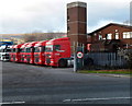
There are currently over 7.5m images from over14,400 individuals and you can help contribute to the project by visiting https://www.geograph.org.uk
Image Map
Images are licensed for reuse under creativecommons.org/licenses/by-sa/2.0
Notes
- Clicking on the map will re-center to the selected point.
- The higher the marker number, the further away the image location is from the centre of the postcode.
Image Listing (287 Images Found)
Images are licensed for reuse under creativecommons.org/licenses/by-sa/2.0
Image
Details
Distance
1
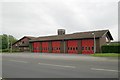
Cwmbran Fire Station
Cwmbran Fire Station, Henllys Way, Cwmbran
Image: © Kevin Hale
Taken: 3 Jun 2007
0.01 miles
2
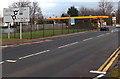
Twin roundabouts ahead, Henllys Way, Cwmbran
The sign is opposite the red doors http://www.geograph.org.uk/photo/467330 of Cwmbran Fire Station. A Shell filling station http://www.geograph.org.uk/photo/1977526 is ahead.
Image: © Jaggery
Taken: 7 Dec 2014
0.03 miles
3
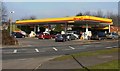
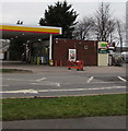
Shell, Henllys Way, Cwmbran
Filling station located opposite the fire station. http://www.geograph.org.uk/photo/467330
Image: © Jaggery
Taken: 6 Feb 2010
0.03 miles
4
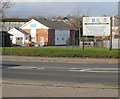
Bellevue Nursery, Cwmbran
Private children's nursery located on Henllys Way, opposite the fire station. http://www.geograph.org.uk/photo/467330
Image: © Jaggery
Taken: 6 Feb 2010
0.03 miles
5
A row of articulated lorry tractor units park near Ty Coch Way, Cwmbran
The units are parked near Cwmbran Fire Station's http://www.geograph.org.uk/photo/467330 training tower.
A tractor unit is also called a road tractor or traction unit. In Australia, the usual term is prime mover. The use of a tractor unit to haul a trailer or semi-trailer gives more flexibility (literally and figuratively) than a rigid vehicle.
Image: © Jaggery
Taken: 1 Dec 2012
0.03 miles
6
Henllys Way bus stop and shelter near a direction sign, Cwmbran
This stop for buses to Cwmbran town centre and bus station.
Image: © Jaggery
Taken: 24 Mar 2018
0.03 miles
7
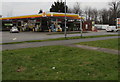
Spar, Subway and Starbucks, Henllys Way, Cwmbran
A small Spar shop is located behind this https://www.geograph.org.uk/photo/5828953 Shell filling station.
Other names in view in March 2018 are Subway and Starbucks.
Image: © Jaggery
Taken: 24 Mar 2018
0.04 miles
8
Shell filling station, Henllys Way, Cwmbran
Image: © Jaggery
Taken: 24 Mar 2018
0.04 miles
9
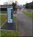
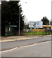
Footpath and cycle route diagram, Henllys Way, Cwmbran
On the south side of Henllys Way, near the Belle Vue Road junction.
A disconnected section of the former Monmouthshire & Brecon canal http://www.geograph.org.uk/photo/4408135 is behind the path on the left.
Image: © Jaggery
Taken: 7 Dec 2014
0.04 miles
10
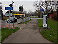
Signs near a Henllys Way pelican crossing, Cwmbran
The sign on the left shows CYCLISTS DISMOUNT and its Welsh equivalent.
Direction signs for National Cycle Network route 49 are on the right.
The red doors on the right are part of Cwmbran Fire Station. http://www.geograph.org.uk/photo/467330
Image: © Jaggery
Taken: 24 Mar 2018
0.04 miles