IMAGES TAKEN NEAR TO
Coed Glas, CWMBRAN, NP44 7PA
Introduction
This page details the photographs taken nearby to Coed Glas, NP44 7PA by members of the Geograph project.
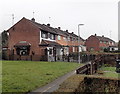
The Geograph project started in 2005 with the aim of publishing, organising and preserving representative images for every square kilometre of Great Britain, Ireland and the Isle of Man.

There are currently over 7.5m images from over14,400 individuals and you can help contribute to the project by visiting https://www.geograph.org.uk
Image Map
Images are licensed for reuse under creativecommons.org/licenses/by-sa/2.0
Notes
- Clicking on the map will re-center to the selected point.
- The higher the marker number, the further away the image location is from the centre of the postcode.
Image Listing (197 Images Found)
Images are licensed for reuse under creativecommons.org/licenses/by-sa/2.0
Image
Details
Distance
1
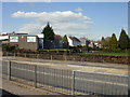
Cwmbran Park
The southern edge of Cwmbran Park viewed from Henllys Way.
Image: © Jaggery
Taken: 8 Apr 2010
0.02 miles
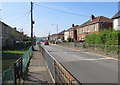
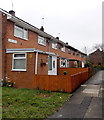
2
Western end of Coed Glas, Cwmbran
The road named Coed Glas viewed across Cocker Avenue from the corner of Waun Road.
Image: © Jaggery
Taken: 24 Mar 2018
0.02 miles
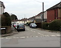
3
Kemys Walk, Cwmbran
Along Kemys Walk towards Coed Glas from Henllys Way.
Image: © Jaggery
Taken: 9 Apr 2017
0.02 miles
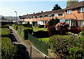
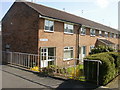
4
Tree-lined row of houses, Coed Glas, Cwmbran
Looking west towards Cocker Avenue.
Image: © Jaggery
Taken: 9 Mar 2013
0.03 miles
5
Kemys Walk houses, Cwmbran
Viewed from the Coed Glas end looking towards Henllys Way.
Image: © Jaggery
Taken: 9 Mar 2013
0.04 miles
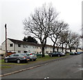
6
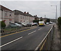
Cocker Avenue, Cwmbran
Looking to the SW along Cocker Avenue from near the corner of Henllys Way.
Image: © Jaggery
Taken: 24 Mar 2018
0.04 miles
7
Cocker Avenue, Cwmbran
Looking to the southwest along Cocker Avenue from the corner of Henllys Way.
Image: © Jaggery
Taken: 9 Apr 2017
0.04 miles
8
Kemys Walk, Two Locks, Cwmbran
Housing adjacent to Henllys Way.
Image: © Jaggery
Taken: 8 Apr 2010
0.04 miles
9
Green Acre houses, Two Locks, Cwmbran
Viewed from the Coed Glas end looking towards Henllys Way.
Image: © Jaggery
Taken: 9 Mar 2013
0.05 miles
10
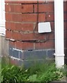
Ordnance Survey Cut Mark
This OS cut mark can be found on No60 Cocker Avenue. It marks a point 71.381m above mean sea level.
Image: © Adrian Dust
Taken: 10 Sep 2020
0.05 miles