IMAGES TAKEN NEAR TO
Heol Y Groes, CWMBRAN, NP44 7LT
Introduction
This page details the photographs taken nearby to Heol Y Groes, NP44 7LT by members of the Geograph project.
The Geograph project started in 2005 with the aim of publishing, organising and preserving representative images for every square kilometre of Great Britain, Ireland and the Isle of Man.

There are currently over 7.5m images from over14,400 individuals and you can help contribute to the project by visiting https://www.geograph.org.uk
Image Map
Images are licensed for reuse under creativecommons.org/licenses/by-sa/2.0
Notes
- Clicking on the map will re-center to the selected point.
- The higher the marker number, the further away the image location is from the centre of the postcode.
Image Listing (74 Images Found)
Images are licensed for reuse under creativecommons.org/licenses/by-sa/2.0
Image
Details
Distance
1
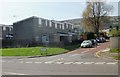
Hollybush Primary School, Cwmbran
Viewed from Ton Road. The school is undergoing building work during the Easter 2010 school holidays.
Image: © Jaggery
Taken: 8 Apr 2010
0.02 miles
2
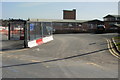
Road into Nant Celyn Primary School, Cwmbran
Viewed through the entrance gates. https://www.geograph.org.uk/photo/5716903 A sign on the left shows a 5 mph speed limit.
Image: © Jaggery
Taken: 24 Mar 2018
0.04 miles
3
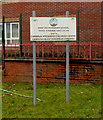
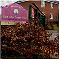
Primary School and Children's Centre nameboard, Cwmbran
The Nant Celyn Primary School and Cwmbran Integrated Children's Centre nameboard
faces Ton Road near these https://www.geograph.org.uk/photo/5716903 entrance gates. The text is also in Welsh.
Image: © Jaggery
Taken: 24 Mar 2018
0.06 miles
4
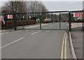
Nant Celyn Primary School entrance gates, Cwmbran
Viewed from Ton Road near the Henllys Way junction.
Notices show No trespassing, no smoking, no dogs. The text is also in Welsh.
Image: © Jaggery
Taken: 24 Mar 2018
0.06 miles
5
Welcome to Nant Celyn Primary School, Cwmbran
The board on the left here https://www.geograph.org.uk/photo/5716909 shows that the school name is Ysgol Gynradd Nant Celyn in Welsh.
Image: © Jaggery
Taken: 24 Mar 2018
0.06 miles
6
No motor vehicles ahead except for access, Ton Road, Cwmbran
The signs are near the entrance to Nant Celyn Primary School and 50 metres from the Henllys Way junction.
Image: © Jaggery
Taken: 24 Mar 2018
0.06 miles
7
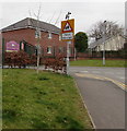
Warning sign - Patrol/Hebryngwr, Ton Road, Cwmbran
The English/Welsh sign is near the dark green entrance gates https://www.geograph.org.uk/photo/5716903 to Nant Celyn Primary School.
Image: © Jaggery
Taken: 24 Mar 2018
0.06 miles
8
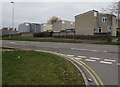
Housing on the west side on Henllys Way, Cwmbran
Viewed from the corner of Ton Road. Jule Road http://www.geograph.org.uk/photo/1794592 is in the background on the far left.
Image: © Jaggery
Taken: 24 Mar 2018
0.06 miles
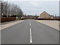
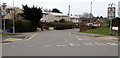
10
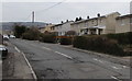
Western end of Ton Road, Cwmbran
On the approach to the Henllys Way junction.
Image: © Jaggery
Taken: 24 Mar 2018
0.07 miles