1
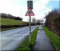
Snow warning traffic sign, Henllys Way, Cwmbran
The roadway here is only about 125 metres (410 feet) above mean sea level, and it is only a few metres higher ahead, so it is strange that there is a permanent snow warning road sign in this location.
Image: © Jaggery
Taken: 15 Dec 2011
0.06 miles
2
Llys Gwyrdd, Henllys, Cwmbran
A view from near the western end of the cul-de-sac Llys Gwyrdd looking in the direction of Henllys Way.
Image: © Jaggery
Taken: 15 Dec 2011
0.06 miles
3
Western side of Llys Gwyrdd, Henllys, Cwmbran
Looking along Llys Gwyrdd towards houses at the western edge of the cul-de-sac.
Llys Gwyrdd connects with Henllys Way behind the camera.
Image: © Jaggery
Taken: 15 Dec 2011
0.07 miles
4
Llys Gwyrdd, Henllys, Cwmbran
A cul-de-sac on the northern side of Henllys Way.
Image: © Jaggery
Taken: 8 Apr 2010
0.07 miles
5
Juniper Crescent, Henllys, Cwmbran
Cul-de-sac on the south side of Birch Grove. Henllys is a suburb in the southwest of Cwmbran.
Image: © Jaggery
Taken: 9 Oct 2016
0.07 miles
6
Campion Close, Henllys, Cwmbran
Viewed from Birch Grove. Campion Close is a cul-de-sac of 12 houses built in 1995.
Image: © Jaggery
Taken: 29 Sep 2011
0.08 miles
7
Southwest edge of Cwmbran
Looking northeastwards along Henllys Way, which marks the southwest edge of Cwmbran.
On the left is the turning for houses in Llys Gwyrdd http://www.geograph.org.uk/photo/1795250 ; on the right is farmland.
Image: © Jaggery
Taken: 8 Apr 2010
0.08 miles
8
Campion Close, Henllys, Cwmbran
Cul-de-sac on the south side of Birch Grove in the Henllys area of southwest Cwmbran.
Image: © Jaggery
Taken: 9 Oct 2016
0.09 miles
9
Children's play area, Henllys, Cwmbran
Located east of Pensarn Way and south of Juniper Crescent.
Image: © Jaggery
Taken: 15 Dec 2011
0.11 miles
10
Junction of Pensarn Way and Birch Grove, Henllys, Cwmbran
The sign warns of humps across Birch Grove for 150 yards. The first one is in view.
Image: © Jaggery
Taken: 9 Oct 2016
0.12 miles


