IMAGES TAKEN NEAR TO
Ton Road, CWMBRAN, NP44 7LF
Introduction
This page details the photographs taken nearby to Ton Road, NP44 7LF by members of the Geograph project.
The Geograph project started in 2005 with the aim of publishing, organising and preserving representative images for every square kilometre of Great Britain, Ireland and the Isle of Man.

There are currently over 7.5m images from over14,400 individuals and you can help contribute to the project by visiting https://www.geograph.org.uk
Image Map
Images are licensed for reuse under creativecommons.org/licenses/by-sa/2.0
Notes
- Clicking on the map will re-center to the selected point.
- The higher the marker number, the further away the image location is from the centre of the postcode.
Image Listing (126 Images Found)
Images are licensed for reuse under creativecommons.org/licenses/by-sa/2.0
Image
Details
Distance
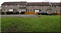
1
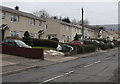
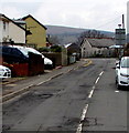
Ton Road houses, Cwmbran
Ton Road is between Two Locks Road and Henllys Way.
Image: © Jaggery
Taken: 24 Mar 2018
0.02 miles
2
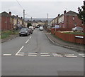
Down Ton Road, Cwmbran
Part of Ton Road's descent from Henllys Way to Two Locks Road.
Image: © Jaggery
Taken: 24 Mar 2018
0.03 miles
3
Sandybrook Close, Cwmbran
Cul-de-sac on the northeast side of Ton Road.
Image: © Jaggery
Taken: 24 Mar 2018
0.06 miles
4
Traffic calming, Ton Road, Cwmbran
Vehicles on the camera side must give way to oncoming vehicles through the narrowed part of Ton Road.
Image: © Jaggery
Taken: 24 Mar 2018
0.06 miles
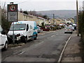
5
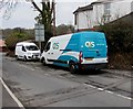
OCS van, Ton Road, Cwmbran
Text on the Renault van shows that OCS is Outsourced Client Solutions.
Image: © Jaggery
Taken: 24 Mar 2018
0.07 miles
6
Hollybush Close houses, Cwmbran
This part of Hollybush Close is near Dowlais Brook and Ton Road.
Image: © Jaggery
Taken: 24 Mar 2018
0.07 miles
7
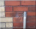
Ordnance Survey Cut Mark
This OS cut mark can be found on No39 Ton Road. It marks a point 75.895m above mean sea level.
Image: © Adrian Dust
Taken: 10 Sep 2020
0.08 miles
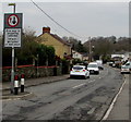
8
Signs near the SE end on Ton Road, Cwmbran
No motors vehicles ahead on Ton Road except for access. The text is also in Welsh.
Image: © Jaggery
Taken: 24 Mar 2018
0.08 miles
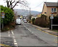
9
Up Ton Road, Cwmbran
Part of Ton Road's ascent from Two Locks Road to Henllys Way.
Image: © Jaggery
Taken: 24 Mar 2018
0.08 miles
10
The Crescent from Cocker Avenue, Cwmbran
One of two junctions of The Crescent and Cocker Avenue. The other one https://www.geograph.org.uk/photo/5716106 is 160 metres to the northeast.
Image: © Jaggery
Taken: 24 Mar 2018
0.09 miles