IMAGES TAKEN NEAR TO
Cae Derwen, CWMBRAN, NP44 7HX
Introduction
This page details the photographs taken nearby to Cae Derwen, NP44 7HX by members of the Geograph project.
The Geograph project started in 2005 with the aim of publishing, organising and preserving representative images for every square kilometre of Great Britain, Ireland and the Isle of Man.

There are currently over 7.5m images from over14,400 individuals and you can help contribute to the project by visiting https://www.geograph.org.uk
Image Map
Images are licensed for reuse under creativecommons.org/licenses/by-sa/2.0
Notes
- Clicking on the map will re-center to the selected point.
- The higher the marker number, the further away the image location is from the centre of the postcode.
Image Listing (195 Images Found)
Images are licensed for reuse under creativecommons.org/licenses/by-sa/2.0
Image
Details
Distance
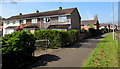
1
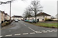
Cae Derwen, Cwmbran
Cae Derwen is a 70 metre long cul-de-sac on the south side of Coed Glas.
Image: © Jaggery
Taken: 9 Mar 2013
0.02 miles
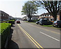
2
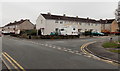
Corner of Trem Twynbarlwm and Coed Glas, Cwmbran
Viewed from Trem Twynbarlwm looking past the right turn into Coed Glas.
Image: © Jaggery
Taken: 9 Mar 2013
0.02 miles
3
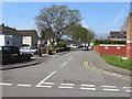
West along Coed Glas, Cwmbran
Viewed across Trem Twynbarlwm. Streets in this part of Cwmbran have Welsh names with no English equivalent shown on street name signs.
Image: © Jaggery
Taken: 9 Apr 2017
0.03 miles
4
Fetty Place Cwmbran
Viewed from Henllys Way. Fetty Place extends for 60 metres to Coed Glas.
Image: © Jaggery
Taken: 9 Apr 2017
0.04 miles
5
South along Trem Twynbarlwm, Cwmbran
From the corner of Henllys Way. The right turn ahead is into Coed Glas. http://www.geograph.org.uk/photo/5412725
Image: © Jaggery
Taken: 9 Apr 2017
0.04 miles
6
Fetty Place, Two Locks, Cwmbran
This is the Coed Glas end of Fetty Place. Its far end is at the edge of Henllys Way.
Image: © Jaggery
Taken: 9 Mar 2013
0.05 miles
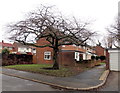
7
Houses on the east side of Trem Twynbarlwm, Cwmbran
Viewed from the corner of Henllys Way.
Image: © Jaggery
Taken: 24 Mar 2018
0.05 miles
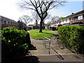
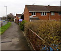
8
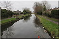
Disused canal south of Henllys Way, Cwmbran
Part of the former Monmouthshire & Brecon Canal which is fragmentary in Cwmbran. For example, there is a 120 metre gap in the canal behind the camera. During the development of Cwmbran New Town from the late 1940s onwards, the course of the canal was severed/built over in many places. The former towpath on the left is now part of National Cycle Network Route 49, a combined cycleway & footpath from Abergavenny to Newport.
Image: © Jaggery
Taken: 24 Mar 2018
0.06 miles
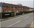
9
Fetty Place houses, Cwmbran
Houses at the northern end of Fetty Place viewed from the Henllys Way pavement.
Image: © Jaggery
Taken: 9 Apr 2017
0.06 miles
10
Houses at the northern end of Fetty Place, Cwmbran
Viewed from the pavement on the south side of Henllys Way.
Image: © Jaggery
Taken: 24 Mar 2018
0.06 miles