IMAGES TAKEN NEAR TO
Henllys, CWMBRAN, NP44 7AZ
Introduction
This page details the photographs taken nearby to NP44 7AZ by members of the Geograph project.
The Geograph project started in 2005 with the aim of publishing, organising and preserving representative images for every square kilometre of Great Britain, Ireland and the Isle of Man.

There are currently over 7.5m images from over14,400 individuals and you can help contribute to the project by visiting https://www.geograph.org.uk
Image Map
Images are licensed for reuse under creativecommons.org/licenses/by-sa/2.0
Notes
- Clicking on the map will re-center to the selected point.
- The higher the marker number, the further away the image location is from the centre of the postcode.
Image Listing (20 Images Found)
Images are licensed for reuse under creativecommons.org/licenses/by-sa/2.0
Image
Details
Distance
1
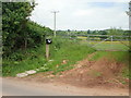
Entrance to Cwm Hen Farm, Henllys Vale
The entrance is on the north side of Pentre Lane, a few metres west of Vale Farm.http://www.geograph.org.uk/photo/1909618
Note: the name of the farm means Old Valley, not the Hen Farm at Cwm !
Image: © Jaggery
Taken: 11 Jun 2010
0.03 miles
2
Vale Farm, Henllys Vale
Viewed from Pentre Road.
Image: © Jaggery
Taken: 11 Jun 2010
0.05 miles
3
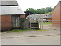
Wooden steps instead of a stile, Vale Farm, Henllys Vale
A public footpath runs through Vale Farm. Access is by the wooden steps beside the farm gate.
Image: © Jaggery
Taken: 11 Jun 2010
0.05 miles
4
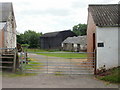
Vale Farm buildings, Henllys Vale
Buildings on the western edge of Vale Farm, viewed from Pentre Lane.
Image: © Jaggery
Taken: 11 Jun 2010
0.05 miles
5
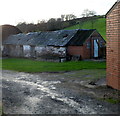
Undulating roof on a Vale Farm building, Henllys Vale
Viewed from Pentre Lane.
Image: © Jaggery
Taken: 15 Dec 2011
0.05 miles
6
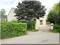
Duffryn Cottage, Henllys Vale
Located on the north side of Pentre Lane, opposite Vale Farm.
Image: © Jaggery
Taken: 11 Jun 2010
0.05 miles
7
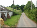
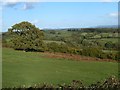
Pentre Lane, Henllys Vale
Viewed from the edge of Vale Farm. The trees in the middle of the photo mark the route ahead. Pentre Lane (and the cameraman) will shortly begin a steep climb up to the level of the houses in the distance.
Image: © Jaggery
Taken: 11 Jun 2010
0.09 miles
8
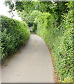
Pentre Lane : steep ascent to Castell-y-bwch
I should have been forewarned by the clues here http://www.geograph.org.uk/photo/1909633 but the length and steepness of the final section of Pentre Lane was a distinctly unpleasant surprise. The view is of the first, relatively gentle, part of the ascent.
Image: © Jaggery
Taken: 11 Jun 2010
0.09 miles
9
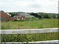
View from the car park at Castell-y-Bwch
Image: © Ruth Sharville
Taken: 16 Oct 2012
0.15 miles
10
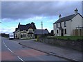
Castell-y-Bwch
The junction with Pentre Lane.
Image: © Roger Cornfoot
Taken: 1 Mar 2007
0.17 miles