IMAGES TAKEN NEAR TO
Trosmawr Road, CWMBRAN, NP44 7AW
Introduction
This page details the photographs taken nearby to Trosmawr Road, NP44 7AW by members of the Geograph project.
The Geograph project started in 2005 with the aim of publishing, organising and preserving representative images for every square kilometre of Great Britain, Ireland and the Isle of Man.

There are currently over 7.5m images from over14,400 individuals and you can help contribute to the project by visiting https://www.geograph.org.uk
Image Map
Images are licensed for reuse under creativecommons.org/licenses/by-sa/2.0
Notes
- Clicking on the map will re-center to the selected point.
- The higher the marker number, the further away the image location is from the centre of the postcode.
Image Listing (3 Images Found)
Images are licensed for reuse under creativecommons.org/licenses/by-sa/2.0
Image
Details
Distance
2
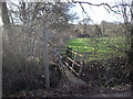
Footbridge, Trawsmawr Lane, Bettws
The footpath and footbridge, as can be seen on the OS 1:25000 map, is in fact just to the north of the stream crossing Trawsmawr Lane, not the south as on the 1:50000 map.
Image: © John Lord
Taken: 26 Feb 2011
0.04 miles
3
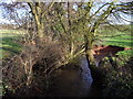
Stream passing under Trawsmawr lane, Bettws
Image: © John Lord
Taken: 26 Feb 2011
0.07 miles