IMAGES TAKEN NEAR TO
Henllys, CWMBRAN, NP44 7AU
Introduction
This page details the photographs taken nearby to NP44 7AU by members of the Geograph project.
The Geograph project started in 2005 with the aim of publishing, organising and preserving representative images for every square kilometre of Great Britain, Ireland and the Isle of Man.

There are currently over 7.5m images from over14,400 individuals and you can help contribute to the project by visiting https://www.geograph.org.uk
Image Map
Images are licensed for reuse under creativecommons.org/licenses/by-sa/2.0
Notes
- Clicking on the map will re-center to the selected point.
- The higher the marker number, the further away the image location is from the centre of the postcode.
Image Listing (11 Images Found)
Images are licensed for reuse under creativecommons.org/licenses/by-sa/2.0
Image
Details
Distance
1

Part of Mill Cottage
An old McCormick tractor sits out back here.
Image: © Jeremy Bolwell
Taken: 11 Nov 2012
0.01 miles
2

Old McCormick tractor
McCormick were an American firm but had a plant in Doncaster, England too. Where this venerable old stager probably originates from.
Image: © Jeremy Bolwell
Taken: 11 Nov 2012
0.02 miles
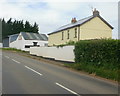
3
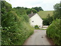
Mill Farm Cottage
Located alongside a sharp bend in the country lane connecting Craig-ceiliog Lane with Henllys Lane.
Image: © Jaggery
Taken: 11 Jun 2010
0.06 miles
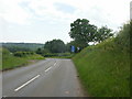
4
Weak bridge ahead
The signs warn of a 13 tonnes maximum gross weight ahead, on a bridge across a stream.
Pont wan is Welsh for weak bridge.
Image: © Jaggery
Taken: 11 Jun 2010
0.12 miles
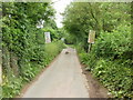
5
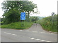
Bend in Craig-ceiliog Lane
Craig-ceiliog Lane which has been following a more-or-less southerly route for the last kilometre, curves to the southeast ahead. The blue sign on the right warns of a weak bridge on a lane which begins opposite the bend.
Image: © Jaggery
Taken: 11 Jun 2010
0.12 miles
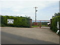
6
13 tonnes gross weight limit ahead
At the start of a lane heading away from Craig-ceiliog Lane, a sign warns of a weight limit (imposed because of a weak bridge).
Image: © Jaggery
Taken: 11 Jun 2010
0.12 miles
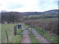
7
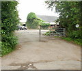
Entrance to Tynewydd Farm
On the tree on the right is a small green RDA (Riding for the Disabled Association) sign.
Image: © Jaggery
Taken: 11 Jun 2010
0.12 miles
8
Ty-coch Farm, Craig-Ceiliog Lane
Farmhouse and farm buildings on the east side of Craig-Ceiliog Lane.
Image: © Jaggery
Taken: 11 Jun 2010
0.18 miles
9
Entrance to Ty-coch Boarding Kennels and Cattery
Part of Ty-coch Farm,http://www.geograph.org.uk/photo/1910018 Craig-ceiliog Lane.
The bottom line of the sign states 'Doggy day care centre'
Image: © Jaggery
Taken: 11 Jun 2010
0.18 miles