IMAGES TAKEN NEAR TO
Henllys, CWMBRAN, NP44 7AT
Introduction
This page details the photographs taken nearby to NP44 7AT by members of the Geograph project.
The Geograph project started in 2005 with the aim of publishing, organising and preserving representative images for every square kilometre of Great Britain, Ireland and the Isle of Man.

There are currently over 7.5m images from over14,400 individuals and you can help contribute to the project by visiting https://www.geograph.org.uk
Image Map
Images are licensed for reuse under creativecommons.org/licenses/by-sa/2.0
Notes
- Clicking on the map will re-center to the selected point.
- The higher the marker number, the further away the image location is from the centre of the postcode.
Image Listing (22 Images Found)
Images are licensed for reuse under creativecommons.org/licenses/by-sa/2.0
Image
Details
Distance
1
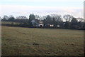
Field south of Henllys Way, Cwmbran
Pasture south of start of minor road to Castell-y-bwch.
Image: © M J Roscoe
Taken: 17 Dec 2019
0.02 miles
2
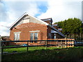
Former Henllys Village Hall, Cwmbran
Now converted to a dwelling, this building named Cariad was formerly Henllys Village Hall.
Though the hall was still fit for purpose its location alongside a busy narrow road was not ideal. The new village hall is here. http://www.geograph.org.uk/photo/2604830
Image: © Jaggery
Taken: 15 Dec 2011
0.07 miles
3
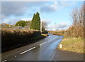
Country lane north of Gelli-fach Farm near Henllys
Viewed from the entrance road to the farm.
Image: © Jaggery
Taken: 15 Dec 2011
0.07 miles
4
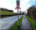
Snow warning traffic sign, Henllys Way, Cwmbran
The roadway here is only about 125 metres (410 feet) above mean sea level, and it is only a few metres higher ahead, so it is strange that there is a permanent snow warning road sign in this location.
Image: © Jaggery
Taken: 15 Dec 2011
0.08 miles
5
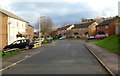
Llys Gwyrdd, Henllys, Cwmbran
A view from near the western end of the cul-de-sac Llys Gwyrdd looking in the direction of Henllys Way.
Image: © Jaggery
Taken: 15 Dec 2011
0.08 miles
6
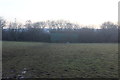
Field and barn south of Henllys Way, Cwmbran
Western part of pasture in Image next to minor road to Castell-y-bwch.
Image: © M J Roscoe
Taken: 17 Dec 2019
0.10 miles
7
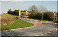
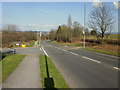
Road south from Henllys to Castell-y-Bwch
Viewed from the edge of Henllys Way at an untypically quiet moment during the evening rush hour.
The road connects with Risca, and the High Cross and Bettws areas of Newport, and is mostly very busy with cars at this time.
Image: © Jaggery
Taken: 8 Apr 2010
0.11 miles
8
Llys Gwyrdd, Henllys, Cwmbran
A cul-de-sac on the northern side of Henllys Way.
Image: © Jaggery
Taken: 8 Apr 2010
0.13 miles
9
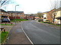
Western side of Llys Gwyrdd, Henllys, Cwmbran
Looking along Llys Gwyrdd towards houses at the western edge of the cul-de-sac.
Llys Gwyrdd connects with Henllys Way behind the camera.
Image: © Jaggery
Taken: 15 Dec 2011
0.13 miles
10
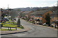
Southwest edge of Cwmbran
Looking northeastwards along Henllys Way, which marks the southwest edge of Cwmbran.
On the left is the turning for houses in Llys Gwyrdd http://www.geograph.org.uk/photo/1795250 ; on the right is farmland.
Image: © Jaggery
Taken: 8 Apr 2010
0.13 miles