IMAGES TAKEN NEAR TO
Coed Eva, CWMBRAN, NP44 7AE
Introduction
This page details the photographs taken nearby to NP44 7AE by members of the Geograph project.
The Geograph project started in 2005 with the aim of publishing, organising and preserving representative images for every square kilometre of Great Britain, Ireland and the Isle of Man.

There are currently over 7.5m images from over14,400 individuals and you can help contribute to the project by visiting https://www.geograph.org.uk
Image Map
Images are licensed for reuse under creativecommons.org/licenses/by-sa/2.0
Notes
- Clicking on the map will re-center to the selected point.
- The higher the marker number, the further away the image location is from the centre of the postcode.
Image Listing (42 Images Found)
Images are licensed for reuse under creativecommons.org/licenses/by-sa/2.0
Image
Details
Distance
1
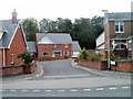
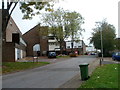
Newer housing, Coed Eva Mill, Cwmbran
Viewed from alongside an older house, Ton Felin. http://www.geograph.org.uk/photo/2639971
Image: © Jaggery
Taken: 9 Oct 2011
0.05 miles
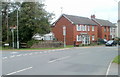
2
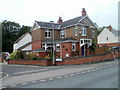
Ton Felin, Coed Eva Mill, Cwmbran
An older detached house in the residential street Coed Eva Mill, surrounded by housing that appears to have been recently built. http://www.geograph.org.uk/photo/2639980
Image: © Jaggery
Taken: 9 Oct 2011
0.05 miles
3
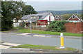
Mill Tavern, Coed Eva, Cwmbran
Pub with its main frontage along a residential street named Coed Eva Mill. This is the other side of the pub, viewed across Two Locks Road.
Image: © Jaggery
Taken: 9 Oct 2011
0.05 miles
4
Coed Eva Mill, Cwmbran
From Ton Road, the road named Coed Eva Mill leads to the cul-de-sac Coed Lee.
Image: © Jaggery
Taken: 24 Mar 2018
0.09 miles
5
East Roedin, Cwmbran
Residential street viewed from the edge of Off Way Stores. http://www.geograph.org.uk/photo/2640331
Image: © Jaggery
Taken: 9 Oct 2011
0.09 miles
6
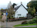
Grade II listed former Glan-y-nant Farmhouse, Cwmbran
Located at the western end of Garth Road. The oldest (western) part of the building is thought to date from the 17th century, with the eastern section probably an early 18th century addition. Grade II listed in September 2002.
Image: © Jaggery
Taken: 9 Oct 2011
0.10 miles
7
Coed Eva Mill houses, Cwmbran
Viewed across Ton Road.
Image: © Jaggery
Taken: 24 Mar 2018
0.10 miles
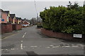
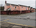
8
Corner of Two Locks Road and Ton Road, Cwmbran
Two Locks Road houses near the left turn into Ton Road.
Image: © Jaggery
Taken: 9 Oct 2011
0.13 miles
9
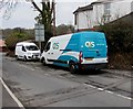
OCS van, Ton Road, Cwmbran
Text on the Renault van shows that OCS is Outsourced Client Solutions.
Image: © Jaggery
Taken: 24 Mar 2018
0.14 miles
10
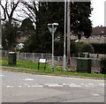
Ton Road telecoms cabinets, Cwmbran
Viewed across Two Locks Road. BT cabinet on the left. Virgin Media cabinet on the right.
Image: © Jaggery
Taken: 24 Mar 2018
0.14 miles