IMAGES TAKEN NEAR TO
Garth Road, CWMBRAN, NP44 7AB
Introduction
This page details the photographs taken nearby to Garth Road, NP44 7AB by members of the Geograph project.
The Geograph project started in 2005 with the aim of publishing, organising and preserving representative images for every square kilometre of Great Britain, Ireland and the Isle of Man.

There are currently over 7.5m images from over14,400 individuals and you can help contribute to the project by visiting https://www.geograph.org.uk
Image Map
Images are licensed for reuse under creativecommons.org/licenses/by-sa/2.0
Notes
- Clicking on the map will re-center to the selected point.
- The higher the marker number, the further away the image location is from the centre of the postcode.
Image Listing (99 Images Found)
Images are licensed for reuse under creativecommons.org/licenses/by-sa/2.0
Image
Details
Distance
1
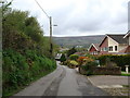
Garth Road beside the disused lime kilns
The lime kilns are shown in image Image
Image: © Ruth Sharville
Taken: 30 Apr 2010
0.03 miles
2
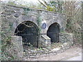
Lime kiln
Early 19 century.Restored by Cwmbran Community Council in 1988
Image: © Colin Madge
Taken: 5 Apr 2008
0.05 miles
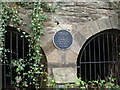
4
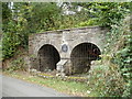
Garth Road lime kilns, Ty Coch, Cwmbran
The plaque states that the early 19th century kilns were restored by Cwmbran Community Council in 1988. Although little is known of the history of the two lime kilns, they had ceased working by 1880. The kilns were used to produce lime by heating limestone at about 900 degrees Celsius. Lime was used for a variety of purposes, such as in the smelting of iron, as a fertiliser, and in making whitewash for exterior walls.
Image: © Jaggery
Taken: 9 Oct 2011
0.05 miles
5
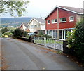
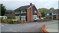
Garth Road houses, Cwmbran
Located near the eastern end of the residential section of Garth Road.
Image: © Jaggery
Taken: 9 Oct 2011
0.05 miles
6
Two Locks Nursery School, Cwmbran
Located roughly halfway along Two Locks Road, near the Llwyn Celyn turning.
Image: © Jaggery
Taken: 6 Feb 2010
0.09 miles
7
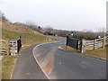
Exit from Llwyncelyn Cemetery, Cwmbran
Looking towards Hollybush Way.
Image: © Jaggery
Taken: 7 Apr 2013
0.09 miles
8
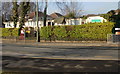
Glan-y-nant Close, Cwmbran
Houses at the western end of the close, viewed across Garth Road.
Image: © Jaggery
Taken: 9 Oct 2011
0.09 miles
9
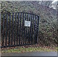
Llwyncelyn Cemetery opening hours notice, Cwmbran
The notice on the gate on the left here https://www.geograph.org.uk/photo/3568310 shows that the cemetery is open from
9am to 7pm during British Summer Time and from 9am to 5pm at all other times.
Image: © Jaggery
Taken: 31 Dec 2023
0.10 miles
10
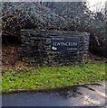
Bilingual cemetery name, Cwmbran
Facing Hollybush Way, alongside the road which ascends to Llwyncelyn Cemetery.
MYNWENT LLWYNCELYN CEMETERY is shown, indicating the Welsh
MYNWENT LLWYNCELYN and the English LLWYNCELYN CEMETERY.
Image: © Jaggery
Taken: 31 Dec 2023
0.10 miles