IMAGES TAKEN NEAR TO
Oaksford, CWMBRAN, NP44 6UN
Introduction
This page details the photographs taken nearby to Oaksford, NP44 6UN by members of the Geograph project.
The Geograph project started in 2005 with the aim of publishing, organising and preserving representative images for every square kilometre of Great Britain, Ireland and the Isle of Man.

There are currently over 7.5m images from over14,400 individuals and you can help contribute to the project by visiting https://www.geograph.org.uk
Image Map
Images are licensed for reuse under creativecommons.org/licenses/by-sa/2.0
Notes
- Clicking on the map will re-center to the selected point.
- The higher the marker number, the further away the image location is from the centre of the postcode.
Image Listing (62 Images Found)
Images are licensed for reuse under creativecommons.org/licenses/by-sa/2.0
Image
Details
Distance
1

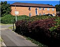
Oaksford, Cwmbran
Houses on the corner of Oaksford, viewed across Ty Gwyn Way.
Image: © Jaggery
Taken: 30 Jan 2011
0.06 miles
2
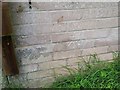
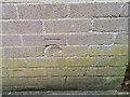
Ordnance Survey Cut Mark
This OS cut mark can be found on No 24 Oaksford. It marks a point 131.050m above mean sea level.
Image: © Adrian Dust
Taken: 17 Aug 2020
0.10 miles
4
Brunel Road, Fairwater, Cwmbran
Houses built c1970, viewed from the corner of Ty Gwyn Way.
Image: © Jaggery
Taken: 30 Jan 2011
0.11 miles
5
East side of Ty Canol Court, Cwmbran
Sheltered housing on the corner of Henllys Way and Ty Canol Row.
Image: © Jaggery
Taken: 10 Jul 2022
0.11 miles
6
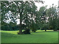
Open Space / Park in Cwmbran
Open ground with a disused children's play area on the left, it wasn't vandal proofed.
Image: © Colin Madge
Taken: 12 Aug 2008
0.11 miles
7
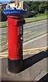
Colourful hat on a Henllys Way pillarbox, Cwmbran
A label on the pillarbox on July 10th 2022 shows
"Made With Love By Henllys Knit and Knatter"
Image: © Jaggery
Taken: 10 Jul 2022
0.13 miles
8
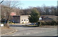
Ty Gwyn Care Home, Fairwater, Cwmbran
Residential care home with accommodation for 34 people. Located at the SE end of Ty Gwyn Road.
Image: © Jaggery
Taken: 30 Jan 2011
0.13 miles
9
Ordnance Survey Cut Mark
This OS cut mark can be found on a NW face of Ty-gwyn Care Home. It marks a point 114.310m above mean sea level.
Image: © Adrian Dust
Taken: 17 Aug 2020
0.14 miles