IMAGES TAKEN NEAR TO
Farlays, CWMBRAN, NP44 6UA
Introduction
This page details the photographs taken nearby to Farlays, NP44 6UA by members of the Geograph project.
The Geograph project started in 2005 with the aim of publishing, organising and preserving representative images for every square kilometre of Great Britain, Ireland and the Isle of Man.

There are currently over 7.5m images from over14,400 individuals and you can help contribute to the project by visiting https://www.geograph.org.uk
Image Map
Images are licensed for reuse under creativecommons.org/licenses/by-sa/2.0
Notes
- Clicking on the map will re-center to the selected point.
- The higher the marker number, the further away the image location is from the centre of the postcode.
Image Listing (45 Images Found)
Images are licensed for reuse under creativecommons.org/licenses/by-sa/2.0
Image
Details
Distance
1
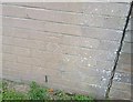
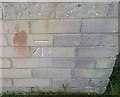
Ordnance Survey Cut Mark
This OS cut mark can be found on No87 Farlays. It marks a point 111.120m above mean sea level.
Image: © Adrian Dust
Taken: 10 Sep 2020
0.04 miles
2
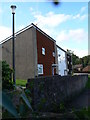
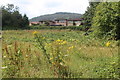
Housing in Cwmbran
Quite a distinct shape in this part of Cwmbran
Image: © Colin Madge
Taken: 12 Aug 2008
0.08 miles
3
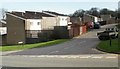
Tolpath, Coed Eva, Cwmbran
Viewed from Henllys Way.
Image: © Jaggery
Taken: 8 Apr 2010
0.08 miles
4
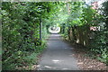
The Incline, by Coed Meyrick-moel, Cwmbran
Looking up a cycle and footpath alongside Coed Meyric-moel local nature reserve (left) Image The incline is on the route of an old tramway from Henllys Colliery down to the Monmouthshire & Brecon Canal.
Image: © M J Roscoe
Taken: 25 Jul 2017
0.09 miles
5
Coed Meyric-moel Local Nature Reserve, Cwmbran
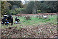
A Gwent Wildlife Trust working party preparing to undertake the annual hay cut of the meadow and other tasks at the Trust's small urban reserve. The oak woodland to the right is also part of the reserve.
Image: © M J Roscoe
Taken: 8 Nov 2016
0.09 miles
6
Coed Meyrick-moel Local Nature Reserve, Cwmbran - Summer
Gwent Wildlife Trust's small reserve; the invasive bracken has been partly cut ready to be removed in order to improve this wildflower meadow. The houses behind are in Ashleigh Court. For a winter view from the other (northwestern) side of the meadow, see Image
Image: © M J Roscoe
Taken: 25 Jul 2017
0.09 miles
7

Coed Waun-fyr, Fairwater, Cwmbran
Coed Waun-fyr is a wood on both sides of Fairwater Way. This view was taken on the north side.
Image: © Jaggery
Taken: 8 Apr 2010
0.10 miles
8
Ordnance Survey Cut Mark
This OS cut mark can be found on No 21 Neerings. It marks a point 109.310m above mean sea level.
Image: © Adrian Dust
Taken: 17 Aug 2020
0.10 miles
9
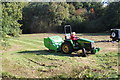
Mowing at Coed Meyrick-moel LNR
Cutting and removing the season's growth on the wildflower meadow on Gwent Wildlife Trust's small suburban reserve
Image: © M J Roscoe
Taken: 9 Oct 2018
0.10 miles
