IMAGES TAKEN NEAR TO
Glanrhyd, CWMBRAN, NP44 6TY
Introduction
This page details the photographs taken nearby to Glanrhyd, NP44 6TY by members of the Geograph project.
The Geograph project started in 2005 with the aim of publishing, organising and preserving representative images for every square kilometre of Great Britain, Ireland and the Isle of Man.

There are currently over 7.5m images from over14,400 individuals and you can help contribute to the project by visiting https://www.geograph.org.uk
Image Map
Images are licensed for reuse under creativecommons.org/licenses/by-sa/2.0
Notes
- Clicking on the map will re-center to the selected point.
- The higher the marker number, the further away the image location is from the centre of the postcode.
Image Listing (26 Images Found)
Images are licensed for reuse under creativecommons.org/licenses/by-sa/2.0
Image
Details
Distance
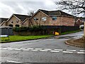
1
Glan Rhyd, Coed Eva, Cwmbran
Looking to the SSW across Penylan Way towards the road named Glan Rhyd.
Image: © Jaggery
Taken: 13 Mar 2022
0.05 miles
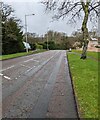
2
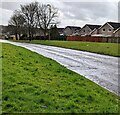
Grassy banks above Penylan Way, Cwmbran
Looking to the ESE along Penylan Way in the Coed Eva area of Cwmbran.
The houses are in the cul-de-sac named Glan Rhyd.
Image: © Jaggery
Taken: 13 Mar 2022
0.05 miles
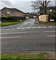
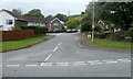
3
Junction of Penylan Way and Glan Rhyd, Cwmbran
Viewed across Penylan Way in the Coed Eva area of Cwmbran. The sign on left shows that Glan Rhyd is not a through route for motor vehicles.
Image: © Jaggery
Taken: 13 Mar 2022
0.06 miles
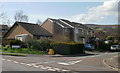
4
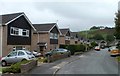
Glan Rhyd, Cwmbran
A view south along the SE section of Glan Rhyd.
Image: © Jaggery
Taken: 9 Oct 2011
0.06 miles
5
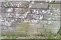
Ordnance Survey Cut Mark
This OS cut mark can be found on the wall of No12 Glan Rhyd. It marks a point 96.960m above mean sea level.
Image: © Adrian Dust
Taken: 10 Sep 2020
0.07 miles
6
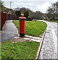
Queen Elizabeth II pillar box, Penylan Way, Cwmbran
In March 2022 a Spring-themed hat https://www.geograph.org.uk/photo/7117964 is on top of the pillar box in the Coed Eva area of Cwmbran.
Image: © Jaggery
Taken: 13 Mar 2022
0.07 miles
7
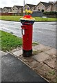
Spring-themed hat on a pillar box, Coed Eva, Cwmbran
Viewed on March 13th 2022. The pillar box is alongside Penylan Way opposite the Glan Rhyd junction.
Image: © Jaggery
Taken: 13 Mar 2022
0.07 miles
8
Meyricks, Coed Eva, Cwmbran
Viewed across Penylan Way. Meyricks is one of several streets in Coed Eva with unusual, one-word names. http://www.geograph.org.uk/photo/2640333
Image: © Jaggery
Taken: 9 Oct 2011
0.09 miles
9
NW along Penylan Way, Cwmbran
In the Coed Eva area of Cwmbran.
Image: © Jaggery
Taken: 13 Mar 2022
0.11 miles
10
Pentre Close, Coed Eva, Cwmbran
Viewed from Henllys Way.
Image: © Jaggery
Taken: 8 Apr 2010
0.14 miles