IMAGES TAKEN NEAR TO
Meyricks, CWMBRAN, NP44 6TU
Introduction
This page details the photographs taken nearby to Meyricks, NP44 6TU by members of the Geograph project.
The Geograph project started in 2005 with the aim of publishing, organising and preserving representative images for every square kilometre of Great Britain, Ireland and the Isle of Man.

There are currently over 7.5m images from over14,400 individuals and you can help contribute to the project by visiting https://www.geograph.org.uk
Image Map
Images are licensed for reuse under creativecommons.org/licenses/by-sa/2.0
Notes
- Clicking on the map will re-center to the selected point.
- The higher the marker number, the further away the image location is from the centre of the postcode.
Image Listing (31 Images Found)
Images are licensed for reuse under creativecommons.org/licenses/by-sa/2.0
Image
Details
Distance
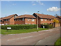
1
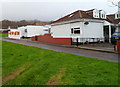
Penylan Way houses, Cwmbran
Penylan Way houses were built with flat roofs, as on the house on the left. Most of the houses have had sloping roofs added, as on the house on the right.
Image: © Jaggery
Taken: 25 Dec 2011
0.05 miles
2
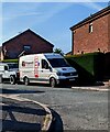
Fitzgerald Plant Services van, Pentre Close, Cwmbran
Text on the van in May 2023 includes "Rail & Construction Equipment Services".
Image: © Jaggery
Taken: 27 May 2023
0.07 miles
3
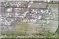
Ordnance Survey Cut Mark
This OS cut mark can be found on the wall of No12 Glan Rhyd. It marks a point 96.960m above mean sea level.
Image: © Adrian Dust
Taken: 10 Sep 2020
0.08 miles
4
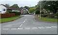
Meyricks, Coed Eva, Cwmbran
Viewed across Penylan Way. Meyricks is one of several streets in Coed Eva with unusual, one-word names. http://www.geograph.org.uk/photo/2640333
Image: © Jaggery
Taken: 9 Oct 2011
0.09 miles
5
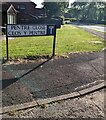
Bilingual Pentre Close sign, Cwmbran
The sign on the corner of Henllys Way shows that Pentre Close is Clos y Pentre in Welsh.
Image: © Jaggery
Taken: 27 May 2023
0.11 miles
6
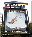
Pub sign, The Blinkin' Owl, Coed Eva, Cwmbran
The owl looks more snoozin' than blinkin'. The pub http://www.geograph.org.uk/photo/2640334 is on the corner of Oxtens and Henllys Way.
Image: © Jaggery
Taken: 9 Oct 2011
0.11 miles
7
The Blinkin' Owl, Coed Eva, Cwmbran
A Brains pub located on the SW corner of Oxtens and Henllys Way. The pub's website describes The Blinkin' Owl as a 'modern community pub'.
Image: © Jaggery
Taken: 9 Oct 2011
0.11 miles
8
The Blinkin' Owl, Coed Eva, Cwmbran
Pub on the corner of Oxtens and Henllys Way.
Image: © Jaggery
Taken: 8 Apr 2010
0.11 miles
9
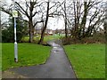
Footbridge across a stream near Henllys Way, Cwmbran
The footbridge gives pedestrians a short cut from Coed Eva and Hollybush Community Hall, http://www.geograph.org.uk/photo/2742133 to Henllys Way across a stream named Nant y milwr.
Image: © Jaggery
Taken: 25 Dec 2011
0.11 miles
10
Perthy Close, Coed Eva, Cwmbran
Viewed from Henllys Way.
Image: © Jaggery
Taken: 8 Apr 2010
0.12 miles