IMAGES TAKEN NEAR TO
Henllys Village Road, CWMBRAN, NP44 6JZ
Introduction
This page details the photographs taken nearby to Henllys Village Road, NP44 6JZ by members of the Geograph project.
The Geograph project started in 2005 with the aim of publishing, organising and preserving representative images for every square kilometre of Great Britain, Ireland and the Isle of Man.

There are currently over 7.5m images from over14,400 individuals and you can help contribute to the project by visiting https://www.geograph.org.uk
Image Map
Images are licensed for reuse under creativecommons.org/licenses/by-sa/2.0
Notes
- Clicking on the map will re-center to the selected point.
- The higher the marker number, the further away the image location is from the centre of the postcode.
Image Listing (128 Images Found)
Images are licensed for reuse under creativecommons.org/licenses/by-sa/2.0
Image
Details
Distance
1
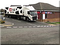
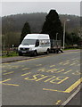
Milk being delivered to a Henllys convenience store, Cwmbran
Viewed across Henllys Village Road in April 2020. A Müller Milk lorry is outside a One Stop shop.
Image: © Jaggery
Taken: 4 Apr 2020
0.01 miles
2
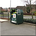
Dark green donations bin above Henllys Village Road, Cwmbran
The One Stop bin is on the southeast side of the One Stop shop.
Text in view in April 2020 includes Donate your clothes & shoes
and Help people in need in your community.
Image: © Jaggery
Taken: 4 Apr 2020
0.01 miles
3
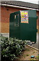
Outdated funfair advert on a donations bin, Henllys, Cwmbran
On the Henllys Village Road side of this https://www.geograph.org.uk/photo/6432554 donations bin viewed on April 4th 2020. The dates shown for the funfair in Grange Road Cwmbran are March 19th - March 29th 2020.
Image: © Jaggery
Taken: 4 Apr 2020
0.01 miles
4
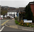
Bilingual name sign on a Henllys corner, Cwmbran
The sign on the corner of Henllys Village Road shows that Bryn Henllys View is Trem Bryn Henllys in Welsh.
The Dorallt https://www.geograph.org.uk/photo/6432330 is in the background.
Image: © Jaggery
Taken: 4 Apr 2020
0.02 miles
5
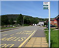
No longer a bus stop, Henllys Village Road, Cwmbran
On May 30th 2016, the bus stop sign shows Dorallt Inn (which is in the background) http://www.geograph.org.uk/photo/4973544 and bus route 25.
A Henllys resident told me that this road is not now a bus route. The 25 service was withdrawn "many years - perhaps a decade - ago". She also said that there are other locations in Cwmbran where bus stop signs and road markings remain despite withdrawal of a bus service.
Image: © Jaggery
Taken: 30 May 2016
0.02 miles
6
Bilingual warning sign alongside Henllys Village Road, Cwmbran
On the approach to a playground (Lle chwarae in Welsh).
Image: © Jaggery
Taken: 7 Dec 2020
0.02 miles
7
E.J.Metcalfe Ltd van and trailer, Henllys Village Road, Cwmbran
Parked while its driver cuts the grass in this https://www.geograph.org.uk/photo/6432366 children's play area in early April 2020. Text on the van includes TREE & GARDEN CONTRACTOR.
Image: © Jaggery
Taken: 4 Apr 2020
0.02 miles
8
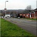
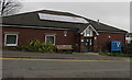
Henllys Village Hall, Cwmbran
Viewed across Henllys Village Road. Henllys Village Hall is opposite the Dorallt Inn. http://www.geograph.org.uk/photo/4973544
Image: © Jaggery
Taken: 30 May 2016
0.02 miles
9
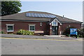
Henllys Village Hall closed until further notice, Cwmbran
Viewed across Henllys Village Road on April 4th 2020. Henllys Village Hall
is closed until further notice during the Coronavirus (COVID-19) global pandemic.
Image: © Jaggery
Taken: 4 Apr 2020
0.02 miles
10
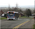
4H bus in Henllys, Cwmbran
In April 2020, a Phil Anslow & Sons Coaches bus descends
Henllys Village Road on bus route 4H to Cwmbran bus station.
Image: © Jaggery
Taken: 4 Apr 2020
0.02 miles