IMAGES TAKEN NEAR TO
Henllys, CWMBRAN, NP44 6HT
Introduction
This page details the photographs taken nearby to NP44 6HT by members of the Geograph project.
The Geograph project started in 2005 with the aim of publishing, organising and preserving representative images for every square kilometre of Great Britain, Ireland and the Isle of Man.

There are currently over 7.5m images from over14,400 individuals and you can help contribute to the project by visiting https://www.geograph.org.uk
Image Map
Images are licensed for reuse under creativecommons.org/licenses/by-sa/2.0
Notes
- Clicking on the map will re-center to the selected point.
- The higher the marker number, the further away the image location is from the centre of the postcode.
Image Listing (45 Images Found)
Images are licensed for reuse under creativecommons.org/licenses/by-sa/2.0
Image
Details
Distance
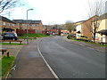
1
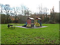
Children's play area, Henllys, Cwmbran
Located east of Pensarn Way and south of Juniper Crescent.
Image: © Jaggery
Taken: 15 Dec 2011
0.06 miles
2
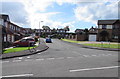
Pant-yr-Heol Close, Henllys, Cwmbran
Cul-de-sac on the south side of Pensarn Way.
Image: © Jaggery
Taken: 9 Oct 2016
0.06 miles
3
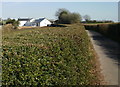
Hedged access road to Cock-y-North Farm, Henllys, Cwmbran
The road connects the farm with Henllys Way.
The unusual name of the farm has similar variants elsewhere in southeast Wales:
Coc-y-North Lane, Rhiwderin. http://www.geograph.org.uk/photo/1780944
Coch-y-North Road, Tranch, Torfaen. http://www.geograph.org.uk/photo/488096
Image: © Jaggery
Taken: 8 Apr 2010
0.06 miles
4
Llys Gwyrdd, Henllys, Cwmbran
A cul-de-sac on the northern side of Henllys Way.
Image: © Jaggery
Taken: 8 Apr 2010
0.06 miles
5
Western side of Llys Gwyrdd, Henllys, Cwmbran
Looking along Llys Gwyrdd towards houses at the western edge of the cul-de-sac.
Llys Gwyrdd connects with Henllys Way behind the camera.
Image: © Jaggery
Taken: 15 Dec 2011
0.06 miles
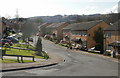
6
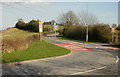
Road south from Henllys to Castell-y-Bwch
Viewed from the edge of Henllys Way at an untypically quiet moment during the evening rush hour.
The road connects with Risca, and the High Cross and Bettws areas of Newport, and is mostly very busy with cars at this time.
Image: © Jaggery
Taken: 8 Apr 2010
0.09 miles
7
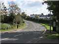
Sunday morning jogger in Henllys Way, Cwmbran
Viewed in October 2016. Though BUS STOP and the Welsh SAFLE BWS are prominently marked on the road surface, no buses have stopped here for several years. The bus stop signs show the defunct Route 25.
Image: © Jaggery
Taken: 9 Oct 2016
0.09 miles
8
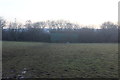
Field and barn south of Henllys Way, Cwmbran
Western part of pasture in Image next to minor road to Castell-y-bwch.
Image: © M J Roscoe
Taken: 17 Dec 2019
0.10 miles
9
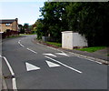
Speed bumps and an electricity substation, Pensarn Way, Henllys, Cwmbran
The Western Power Distribution electricity substation identifier is BARRATTS COCK-Y-NORTH S/S No 531903.
Image: © Jaggery
Taken: 9 Oct 2016
0.10 miles
10
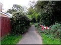
Brookside path, Henllys, Cwmbran
On the north side of Pensarn Way, this path is at the edge of a tree-lined
unnamed brook, a tributary of a larger brook named Nant y Milwr.
Image: © Jaggery
Taken: 9 Oct 2016
0.10 miles