IMAGES TAKEN NEAR TO
Longhouse Grove, CWMBRAN, NP44 6HQ
Introduction
This page details the photographs taken nearby to Longhouse Grove, NP44 6HQ by members of the Geograph project.
The Geograph project started in 2005 with the aim of publishing, organising and preserving representative images for every square kilometre of Great Britain, Ireland and the Isle of Man.

There are currently over 7.5m images from over14,400 individuals and you can help contribute to the project by visiting https://www.geograph.org.uk
Image Map
Images are licensed for reuse under creativecommons.org/licenses/by-sa/2.0
Notes
- Clicking on the map will re-center to the selected point.
- The higher the marker number, the further away the image location is from the centre of the postcode.
Image Listing (127 Images Found)
Images are licensed for reuse under creativecommons.org/licenses/by-sa/2.0
Image
Details
Distance
1
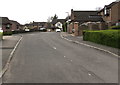
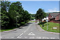
Longhouse Grove, Henllys, Cwmbran
Cul-de-sac on the southwest side of Henllys Village Road.
Image: © Jaggery
Taken: 4 Apr 2020
0.02 miles
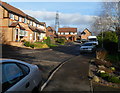
2
Henllys Village Road, Cwmbran
The road heads away from Henllys Way towards Henllys village.
Image: © Jaggery
Taken: 8 Apr 2010
0.04 miles
3
Western side of Wern Fach Court, Henllys, Cwmbran
Viewed from the Pensarn Way end. Wern Fach Court is a cul-de-sac of 24 houses built in the early 1990s.
Image: © Jaggery
Taken: 7 Jan 2012
0.04 miles
4
Junction of Henllys Village Road and Longhouse Grove, Cwmbran
From the left, Longhouse Grove joins Henllys Village Road.
Image: © Jaggery
Taken: 4 Apr 2020
0.05 miles
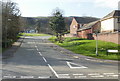
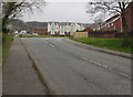
5
Henllys Village Road, Cwmbran
Henllys Village Road ascends from Henllys Way. Before the Second World War, Henllys was a small village with a population of c250. With the development (from 1949 onwards) of Cwmbran New Town, Henllys is now a suburb in the southwest of Cwmbran.
Image: © Jaggery
Taken: 30 May 2016
0.05 miles
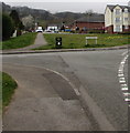
6
Humps warning sign, Henllys Way, Cwmbran
Facing the Pensarn Way junction, the sign warns of speed humps
across Henllys Way for 500 yards to the left and 100 yards to the right.
Image: © Jaggery
Taken: 9 Oct 2016
0.05 miles
7
Up Henllys Village Road, Cwmbran
From Henllys Way, Henllys Village Road ascends towards the Longhouse Grove junction on the left.
Image: © Jaggery
Taken: 4 Apr 2020
0.05 miles
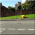
8
Bench alongside Henllys Way, Cwmbran
Located near the Henllys Village Road junction viewed in December 2020.
The bench is not in a May 2018 Google Street View of this location.
Image: © Jaggery
Taken: 7 Dec 2020
0.06 miles
9
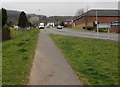
Pavement between grass, Henllys Village Road, Cwmbran
In the background on the left here. https://www.geograph.org.uk/photo/6435409
Image: © Jaggery
Taken: 4 Apr 2020
0.06 miles
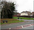
10
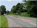
Pedestrian refuge in Henllys Way, Cwmbran
Giving walkers the option to cross half the road width at a time when there is much traffic passing by.
Image: © Jaggery
Taken: 30 May 2016
0.06 miles