IMAGES TAKEN NEAR TO
Twmbarlwm Rise, CWMBRAN, NP44 6EB
Introduction
This page details the photographs taken nearby to Twmbarlwm Rise, NP44 6EB by members of the Geograph project.
The Geograph project started in 2005 with the aim of publishing, organising and preserving representative images for every square kilometre of Great Britain, Ireland and the Isle of Man.

There are currently over 7.5m images from over14,400 individuals and you can help contribute to the project by visiting https://www.geograph.org.uk
Image Map
Images are licensed for reuse under creativecommons.org/licenses/by-sa/2.0
Notes
- Clicking on the map will re-center to the selected point.
- The higher the marker number, the further away the image location is from the centre of the postcode.
Image Listing (67 Images Found)
Images are licensed for reuse under creativecommons.org/licenses/by-sa/2.0
Image
Details
Distance
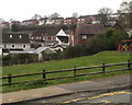
1
Dorallt Way, Henllys, Cwmbran
These are some of the 45 houses in Dorallt Way, built c2001.
Image: © Jaggery
Taken: 16 Sep 2011
0.06 miles
2
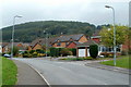
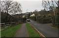
Towards houses on higher ground, Henllys, Cwmbran
Dorallt Way houses on higher ground in the background viewed from Henllys Village Road.
Image: © Jaggery
Taken: 4 Apr 2020
0.08 miles
3
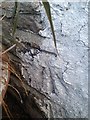
Ordnance Survey Cut Mark
This OS cut mark can be found on No 2 Four Houses. It marks a point 193.749m above mean sea level.
Image: © Adrian Dust
Taken: 17 Aug 2020
0.10 miles
4
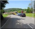
West along Dorallt Way, Henllys, Cwmbran
Suburban road in the southwest of Cwmbran.
Image: © Jaggery
Taken: 30 May 2016
0.12 miles
5
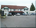
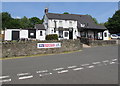
Cwrt Henllys Hotel, Cwmbran
Country inn and restaurant in the Henllys area of SW Cwmbran. A function room accommodating up to 70 people is available to hire for weddings or private parties. Bed and breakfast accommodation is available.
Image: © Jaggery
Taken: 16 Sep 2011
0.12 miles
6
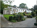
Old Row, Henllys, Cwmbran
A row of six houses built c1830 on the west side of The Incline, a former tramway. http://www.geograph.org.uk/photo/2604568
Image: © Jaggery
Taken: 16 Sep 2011
0.13 miles
7
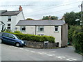
Bellevue Terrace, Henllys, Cwmbran
This is one of a row of three cottages on the corner of Incline Lane. They were built in 1875 alongside the now dismantled tramway. http://www.geograph.org.uk/photo/2604568
Bellevue Terrace 1875 is inscribed in stone between the two larger upstairs windows.
Image: © Jaggery
Taken: 16 Sep 2011
0.13 miles
8
Blaen-y-cwm View, Henllys, Cwmbran
Viewed from the edge of Dorallt Way. Blaen-y-cwm View is a small cul-de-sac of 9 houses built c1995.
Image: © Jaggery
Taken: 16 Sep 2011
0.13 miles
9
Pavement and roadway, Henllys Lane, Cwmbran
Looking to the southwest from the corner of Henllys Village Road.
Image: © Jaggery
Taken: 7 Dec 2020
0.14 miles
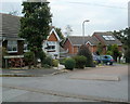
10
Dorallt, Henllys, Cwmbran
The Dorallt Inn is opposite Henllys Village Road. http://www.geograph.org.uk/photo/4973562 to the name sign.
Image: © Jaggery
Taken: 30 May 2016
0.14 miles