IMAGES TAKEN NEAR TO
Craig Road, CWMBRAN, NP44 5YY
Introduction
This page details the photographs taken nearby to Craig Road, NP44 5YY by members of the Geograph project.
The Geograph project started in 2005 with the aim of publishing, organising and preserving representative images for every square kilometre of Great Britain, Ireland and the Isle of Man.

There are currently over 7.5m images from over14,400 individuals and you can help contribute to the project by visiting https://www.geograph.org.uk
Image Map
Images are licensed for reuse under creativecommons.org/licenses/by-sa/2.0
Notes
- Clicking on the map will re-center to the selected point.
- The higher the marker number, the further away the image location is from the centre of the postcode.
Image Listing (55 Images Found)
Images are licensed for reuse under creativecommons.org/licenses/by-sa/2.0
Image
Details
Distance
1
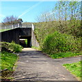
Ty Gwyn Way underpass, Cwmbran
A path from Cwmbran High School passes under Ty Gwyn Way.
Image: © Jaggery
Taken: 9 Apr 2017
0.06 miles
2
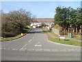
Marlborough Road, Greenmeadow, Cwmbran
Marlborough Road heads away from the junction with Ty Gwyn Way.
Image: © Jaggery
Taken: 30 Jan 2011
0.06 miles
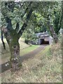
4
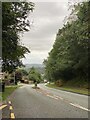
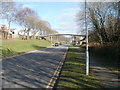
Craig Road, Cwmbran
Viewed from near Ty Canol Way. Craig Road follows a semi-rural route towards the western edge of residential Cwmbran.
Image: © Jaggery
Taken: 30 Jan 2011
0.07 miles
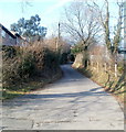
5
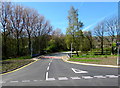
Junction of Ty Gwyn Way and Ty Canol Way, Cwmbran
Ty Canol Way viewed across Ty Gwyn Way.
Image: © Jaggery
Taken: 9 Apr 2017
0.08 miles
7
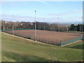
Football pitch, Fairwater High School, Cwmbran
Viewed from Ty Gwyn Road. The football pitch is at the northern end of the school site.
Image: © Jaggery
Taken: 30 Jan 2011
0.09 miles
8
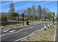
Pelican crossing on a hump, Ty Gwyn Way, Cwmbran
Near the main entrance http://www.geograph.org.uk/photo/5342645 to Cwmbran High School.
Painted white triangles on the road surface draw attention to the hump.
Image: © Jaggery
Taken: 9 Apr 2017
0.10 miles
9
Footbridge from Bedford Close to Barnets, Cwmbran
The footbridge above Ty Gwyn Road connects Bedford Close http://www.geograph.org.uk/photo/2287235 on the left with a group of houses on the right in Barnets.
Image: © Jaggery
Taken: 30 Jan 2011
0.11 miles
10
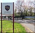
Welcome to Cwmbran High School, Cwmbran
The Welcome faces Ty Gwyn Way, viewed in April 2017. The Torfaen County Borough website states
"As part of Torfaen's 21st Century Schools Programme and following a period of statutory consultation, it was approved by the Council to close Fairwater and Llantarnam Secondary Schools at the end of the 2014/15 academic year. These schools have been replaced by a new school which has been established on the existing Fairwater site. The new school is called Cwmbran High School and opened in September 2015."
Image: © Jaggery
Taken: 9 Apr 2017
0.11 miles