IMAGES TAKEN NEAR TO
Usk Court, CWMBRAN, NP44 5UP
Introduction
This page details the photographs taken nearby to Usk Court, NP44 5UP by members of the Geograph project.
The Geograph project started in 2005 with the aim of publishing, organising and preserving representative images for every square kilometre of Great Britain, Ireland and the Isle of Man.

There are currently over 7.5m images from over14,400 individuals and you can help contribute to the project by visiting https://www.geograph.org.uk
Image Map
Images are licensed for reuse under creativecommons.org/licenses/by-sa/2.0
Notes
- Clicking on the map will re-center to the selected point.
- The higher the marker number, the further away the image location is from the centre of the postcode.
Image Listing (68 Images Found)
Images are licensed for reuse under creativecommons.org/licenses/by-sa/2.0
Image
Details
Distance
1
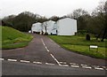
Usk Court, Thornhill, Cwmbran
Usk Court is a cul-de-sac on the southeast side of Hafren Road.
Image: © Jaggery
Taken: 29 Mar 2017
0.02 miles
2
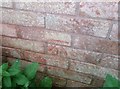
Ordnance Survey Cut Mark
This OS cut mark can be found on No4 Usk Court. It marks a point 160.170m above mean sea level.
Image: © Adrian Dust
Taken: 17 Aug 2020
0.03 miles
3
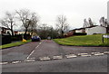
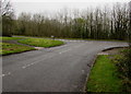
Junction of Hafren Road and Thornhill Road, Thornhill, Cwmbran
Hafren Road ascends away from Thornhill Road.
This is one of two Hafren Road/Thornhill Road junctions in Cwmbran.
The other one is 400 metres to the north. http://www.geograph.org.uk/photo/5329692
Image: © Jaggery
Taken: 29 Mar 2017
0.05 miles
4
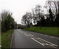
South along Thornhill Road, Thornhill, Cwmbran
Thornhill Road towards Ty Gwyn Way and the Greenmeadow area of Cwmbran.
Image: © Jaggery
Taken: 29 Mar 2017
0.05 miles
5
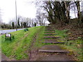
Steps up from Hafren Road, Thornhill, Cwmbran
The steps lead up to a path to houses in Usk Court.
Image: © Jaggery
Taken: 29 Mar 2017
0.06 miles
6
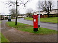
Queen Elizabeth II pillarbox in Thornhill, Cwmbran
Alongside Hafren Road in the Thornhill area of Cwmbran.
Image: © Jaggery
Taken: 29 Mar 2017
0.08 miles
7
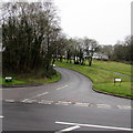
Junction of Hafren Road and Thornhill Road, Thornhill, Cwmbran
Hafren Road descends towards Thornhill Road. This is one of two Hafren Road/Thornhill Road
junctions in Cwmbran. The other one is 400 metres to the north. http://www.geograph.org.uk/photo/5329692
Image: © Jaggery
Taken: 29 Mar 2017
0.08 miles
8
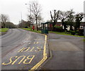
Hafren Road bus stop and shelter, Thornhill, Cwmbran
In March 2017, this stop is part of bus route 1 from Cwmbran bus station. The route is operated by Stagecoach.
Image: © Jaggery
Taken: 29 Mar 2017
0.08 miles
9
Sirhowy Court, Thornhill, Cwmbran
Sirhowy Court is a cul-de-sac on the west side of Hafren Road.
Image: © Jaggery
Taken: 29 Mar 2017
0.08 miles
10
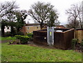
Hafren Road electricity substation, Thornhill, Cwmbran
The Western Power Distribution electricity substation is in a brick enclosure below the east side of Hafren Road. Its identifier is S/S 53-1951.
Image: © Jaggery
Taken: 29 Mar 2017
0.08 miles