IMAGES TAKEN NEAR TO
Marl Court, CWMBRAN, NP44 5TY
Introduction
This page details the photographs taken nearby to Marl Court, NP44 5TY by members of the Geograph project.
The Geograph project started in 2005 with the aim of publishing, organising and preserving representative images for every square kilometre of Great Britain, Ireland and the Isle of Man.

There are currently over 7.5m images from over14,400 individuals and you can help contribute to the project by visiting https://www.geograph.org.uk
Image Map
Images are licensed for reuse under creativecommons.org/licenses/by-sa/2.0
Notes
- Clicking on the map will re-center to the selected point.
- The higher the marker number, the further away the image location is from the centre of the postcode.
Image Listing (47 Images Found)
Images are licensed for reuse under creativecommons.org/licenses/by-sa/2.0
Image
Details
Distance
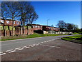
1
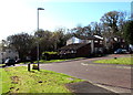
Marl Court, Thornhill, Cwmbran
Cul-de-sac viewed from the corner of Hafren Road.
Image: © Jaggery
Taken: 6 Apr 2017
0.01 miles
2
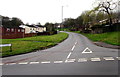
Northeast end of Hafren Road, Upper Cwmbran
Hafren Road ascends from Thornhill Road.
This is one of two Hafren Road/Thornhill Road junctions in Cwmbran.
The other one is 400 metres to the south. http://www.geograph.org.uk/photo/5329624
Image: © Jaggery
Taken: 29 Mar 2017
0.03 miles
3
Hafren Road telecoms cabinets, Thornhill, Cwmbran
Alongside Hafren Road between the Marl Court junction and the Bagley Court junction.
Image: © Jaggery
Taken: 6 Apr 2017
0.03 miles
4
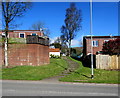
Steps up to Bagley Court, Thornhill, Cwmbran
Ascending from Hafren Road.
Image: © Jaggery
Taken: 6 Apr 2017
0.05 miles
5
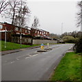
Junction of Marl Court and Hafren Road, Thornhill, Cwmbran
Marl Court from the right joins Hafren Road.
Image: © Jaggery
Taken: 6 Apr 2017
0.05 miles
6
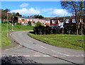
Bagley Court, Thornhill, Cwmbran
Cul-de-sac above Hafren Road.
Image: © Jaggery
Taken: 6 Apr 2017
0.06 miles
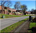
7
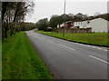
Thornhill Road descends from Upper Cwmbran towards Thornhill
The Welcome to Thornhill signs http://www.geograph.org.uk/photo/5329613 are in the distance.
Image: © Jaggery
Taken: 29 Mar 2017
0.07 miles
8
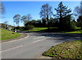
Junction of Hafren Road and Thornhill Road, Upper Cwmbran
Viewed across Hafren Road. This is one of two Hafren Road/Thornhill Road junctions in Cwmbran.
The other one is 400 metres to the south. http://www.geograph.org.uk/photo/5328543
Image: © Jaggery
Taken: 6 Apr 2017
0.07 miles
9
Pedestrian refuge in Thornhill Road, Upper Cwmbran
When Thornhill Road is busy with traffic, the refuge lets walkers cross half the road width at a time.
Image: © Jaggery
Taken: 29 Mar 2017
0.08 miles
10
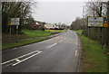
Welcome to Upper Cwmbran - Please drive carefully
Thornhill Road from Thornhill reaches the Upper Cwmbran boundary signs.
Welcome to Thornhill signs http://www.geograph.org.uk/photo/5329613 are on the back of these signs.
Image: © Jaggery
Taken: 29 Mar 2017
0.08 miles