IMAGES TAKEN NEAR TO
Chestnut Green, CWMBRAN, NP44 5TH
Introduction
This page details the photographs taken nearby to Chestnut Green, NP44 5TH by members of the Geograph project.
The Geograph project started in 2005 with the aim of publishing, organising and preserving representative images for every square kilometre of Great Britain, Ireland and the Isle of Man.

There are currently over 7.5m images from over14,400 individuals and you can help contribute to the project by visiting https://www.geograph.org.uk
Image Map
Images are licensed for reuse under creativecommons.org/licenses/by-sa/2.0
Notes
- Clicking on the map will re-center to the selected point.
- The higher the marker number, the further away the image location is from the centre of the postcode.
Image Listing (91 Images Found)
Images are licensed for reuse under creativecommons.org/licenses/by-sa/2.0
Image
Details
Distance
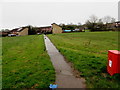
1
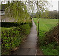
Upper Cwmbran path between houses and a field
Descending from Thornhill Road towards Greenwood Avenue.
Image: © Jaggery
Taken: 29 Mar 2017
0.06 miles
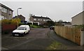
2
Sycamore Place, Upper Cwmbran
On the east side of Thornhill Road.
Image: © Jaggery
Taken: 29 Mar 2017
0.06 miles
3
Cedar Walk, Upper Cwmbran
Cedar Walk leads to Sycamore Place, Chestnut Green and Laurel Green.
Image: © Jaggery
Taken: 29 Mar 2017
0.07 miles
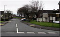
4
Thornhill Road semis, Upper Cwmbran
Semi-detached houses on the east side of Thornhill Road, south of the Sycamore Place junction.
Image: © Jaggery
Taken: 29 Mar 2017
0.10 miles
5
Path through an Upper Cwmbran field
From Cedar Walk to Aran Court.
Image: © Jaggery
Taken: 29 Mar 2017
0.11 miles
6
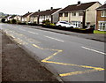
Zigzag markings on Thornhill Road, Upper Cwmbran
The yellow markings define the Keep Clear Zone near Woodlands Community Primary School. A nearby notice states that vehicles must not stop on these markings from 8:30am to 4:30pm Mondays-Fridays.
Image: © Jaggery
Taken: 29 Mar 2017
0.11 miles
7
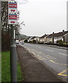
Cold Calling Control Zone notice, Upper Cwmbran
The Trading Standards notice is on a lamppost alongside Thornhill Road.
The notice states that this area is a Cold Calling Control Zone
and shows a number to phone if you are cold called.
Cold calling is the contacting by businesses or their agents of people
thought to be potential customers, without the contact having been prearranged.
Image: © Jaggery
Taken: 29 Mar 2017
0.11 miles
8
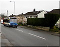
Stagecoach bus, Thornhill Road, Upper Cwmbran
On bus route 1 from Cwmbran bus station to the Thornhill area of Cwmbran.
Image: © Jaggery
Taken: 29 Mar 2017
0.12 miles
9
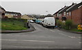
Western arm of Maendy Way, Cwmbran
At right angles to the main course of Maendy Road, this road leads to Greenwood Avenue.
Image: © Jaggery
Taken: 29 Mar 2017
0.12 miles
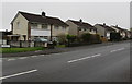
10
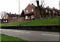
Brick houses and wall above Maendy Way, Cwmbran
Between Maendy Way and Greenwood Avenue.
Image: © Jaggery
Taken: 29 Mar 2017
0.12 miles