IMAGES TAKEN NEAR TO
Rhymney Court, CWMBRAN, NP44 5SG
Introduction
This page details the photographs taken nearby to Rhymney Court, NP44 5SG by members of the Geograph project.
The Geograph project started in 2005 with the aim of publishing, organising and preserving representative images for every square kilometre of Great Britain, Ireland and the Isle of Man.

There are currently over 7.5m images from over14,400 individuals and you can help contribute to the project by visiting https://www.geograph.org.uk
Image Map
Images are licensed for reuse under creativecommons.org/licenses/by-sa/2.0
Notes
- Clicking on the map will re-center to the selected point.
- The higher the marker number, the further away the image location is from the centre of the postcode.
Image Listing (37 Images Found)
Images are licensed for reuse under creativecommons.org/licenses/by-sa/2.0
Image
Details
Distance
1
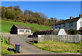
Park House Farm, Upper Cwmbran
Viewed from Rhymney Court in the Thornhill area of Cwmbran in April 2017.
Formerly in an isolated location at the western edge of Cwmbran,
Park House Farm is now at the edge of the Thornhill estate which was built in the 1970s.
Image: © Jaggery
Taken: 6 Apr 2017
0.04 miles
2
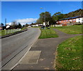
Up Hafren Road, Thornhill, Cwmbran
Hafren Road is the main road through the Thornhill area of Cwmbran.
The Leadon Court junction is behind the railings on the left.
Image: © Jaggery
Taken: 6 Apr 2017
0.05 miles
3
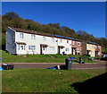
Rhymney Court houses, Thornhill, Cwmbran
Rhymney Court is between Hafren Road and Graig Road.
Image: © Jaggery
Taken: 6 Apr 2017
0.06 miles
4
Shil Pharmacy, Thornhill, Cwmbran
Independent pharmacy in Leadon Court.
Image: © Jaggery
Taken: 6 Apr 2017
0.07 miles
5
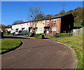
Rhymney Court, Thornhill, Cwmbran
This is a small part of Rhymney Court, an area of houses extending for 275 metres, located between Hafren Road and Graig Road. The path on the right leads to Park House Farm http://www.geograph.org.uk/photo/5339884 in Upper Cwmbran.
Image: © Jaggery
Taken: 6 Apr 2017
0.07 miles
6
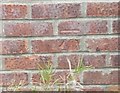
Ordnance Survey Cut Mark
This OS cut mark can be found on the bungalow (No13) north side of Hafren Road. It marks a point 183.480m above mean sea level.
Image: © Adrian Dust
Taken: 17 Aug 2020
0.07 miles
7
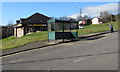
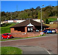
Hafren Road bus stop and shelter, Thornhill, Cwmbran
Near Leadon Court. Thornhill Foodstore and post office are in the background.
Image: © Jaggery
Taken: 6 Apr 2017
0.08 miles
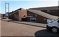
8
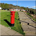
Queen Elizabeth II pillarbox alongside steps, Leadon Court, Thornhill, Cwmbran
Located here. http://www.geograph.org.uk/photo/5339864
Image: © Jaggery
Taken: 6 Apr 2017
0.08 miles
9
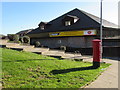
Thornhill Foodstore and post office, Leadon Court, Thornhill, Cwmbran
A post office is inside this Premier convenience store.
Image: © Jaggery
Taken: 6 Apr 2017
0.09 miles
10
Ruby's Bar & Grill, Leadon Court, Thornhill, Cwmbran
Viewed in April 2017. A May 2011 Google Earth Street View shows the boarded-up former Kingfisher pub here.
Image: © Jaggery
Taken: 6 Apr 2017
0.09 miles