IMAGES TAKEN NEAR TO
Maendy Way, CWMBRAN, NP44 5LF
Introduction
This page details the photographs taken nearby to Maendy Way, NP44 5LF by members of the Geograph project.
The Geograph project started in 2005 with the aim of publishing, organising and preserving representative images for every square kilometre of Great Britain, Ireland and the Isle of Man.

There are currently over 7.5m images from over14,400 individuals and you can help contribute to the project by visiting https://www.geograph.org.uk
Image Map
Images are licensed for reuse under creativecommons.org/licenses/by-sa/2.0
Notes
- Clicking on the map will re-center to the selected point.
- The higher the marker number, the further away the image location is from the centre of the postcode.
Image Listing (45 Images Found)
Images are licensed for reuse under creativecommons.org/licenses/by-sa/2.0
Image
Details
Distance
1
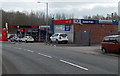
Colley Motors, Cwmbran
Car sales business and Texaco filling station viewed across Maendy Way.
Image: © Jaggery
Taken: 9 Apr 2014
0.01 miles
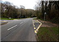
2
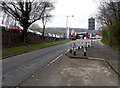
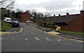
Traffic calming on Maendy Way opposite Colley Motors, Cwmbran
This is one of several roadway narrowings designed to slow down traffic along Maendy Way.
Image: © Jaggery
Taken: 9 Apr 2014
0.02 miles
3
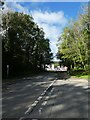
Maendy Way leading to industrial buildings
Image: © David Smith
Taken: 29 Sep 2021
0.02 miles
4
Footpath and cycleway on the north side of Maendy Way, Cwmbran
Opposite Colley Motors. http://www.geograph.org.uk/photo/3926408
Image: © Jaggery
Taken: 9 Apr 2014
0.04 miles
5
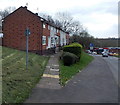
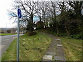
Path to a row of Maendy Way houses, Cwmbran
The corner of Bryn Celyn Road is a few metres behind the camera.
Image: © Jaggery
Taken: 9 Apr 2014
0.04 miles
6
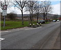
Traffic calming along Maendy Way, Cwmbran
One of several locations along Maendy Way where the road has been narrowed to slow down traffic.
Image: © Jaggery
Taken: 9 Apr 2014
0.05 miles
7
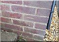
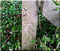
Ordnance Survey Cut Mark
This OS cut mark can be found on No143 Maendy Way. It marks a point 110.990m above mean sea level.
Image: © Adrian Dust
Taken: 17 Aug 2020
0.08 miles
8
Bus stop in woodland, Cwmbran
This part of Maendy Way is through Church Wood. The bus stop is opposite Trinity Road. http://www.geograph.org.uk/photo/3926438
Image: © Jaggery
Taken: 9 Apr 2014
0.08 miles
9
Ordnance Survey Cut Mark
This OS cut mark can be found on a concrete post south side of Maendy Way. It marks a point 95.570m above mean sea level.
Image: © Adrian Dust
Taken: 17 Aug 2020
0.08 miles
10
Coed Cae, Cwmbran
A cul-de-sac on the SE side of Bryn Celyn Road.
Image: © Jaggery
Taken: 9 Apr 2014
0.08 miles