IMAGES TAKEN NEAR TO
Adit Walk, CWMBRAN, NP44 5HX
Introduction
This page details the photographs taken nearby to Adit Walk, NP44 5HX by members of the Geograph project.
The Geograph project started in 2005 with the aim of publishing, organising and preserving representative images for every square kilometre of Great Britain, Ireland and the Isle of Man.

There are currently over 7.5m images from over14,400 individuals and you can help contribute to the project by visiting https://www.geograph.org.uk
Image Map
Images are licensed for reuse under creativecommons.org/licenses/by-sa/2.0
Notes
- Clicking on the map will re-center to the selected point.
- The higher the marker number, the further away the image location is from the centre of the postcode.
Image Listing (70 Images Found)
Images are licensed for reuse under creativecommons.org/licenses/by-sa/2.0
Image
Details
Distance
1
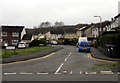
Channel View, West Pontnewydd, Cwmbran
From Maendy Way, Channel View leads to Adit Walk and Greenwood Avenue.
Image: © Jaggery
Taken: 29 Mar 2017
0.05 miles
2
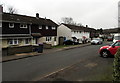
Maendy Wood Rise, West Pontnewydd, Cwmbran
From the corner of Heol y Pwca along Maendy Wood Rise towards Maendy Way.
Image: © Jaggery
Taken: 29 Mar 2017
0.06 miles
3
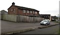
Fenced off former Yew Tree pub, West Pontnewydd, Cwmbran
Former pub on the corner of Maendy Way and Maendy Wood Rise, viewed in March 2017.
The pub closed down in January 2013. http://www.geograph.org.uk/photo/5328902 to the name sign.
Image: © Jaggery
Taken: 29 Mar 2017
0.07 miles
4
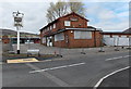
The Yew Tree boarded up and fenced off, Cwmbran
A former pub on the corner of Maendy Way and Maendy Wood Rise, viewed in April 2014.
Image: © Jaggery
Taken: 9 Apr 2014
0.07 miles
5
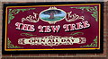
Yew Tree name sign, West Pontnewydd, Cwmbran
On the side of this http://www.geograph.org.uk/photo/5328896 derelict former pub.
Image: © Jaggery
Taken: 29 Mar 2017
0.07 miles
6
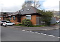
Maendy Square Health Clinic, Cwmbran
On the corner of Maendy Wood Rise and Heol-y-Pwca.
Image: © Jaggery
Taken: 9 Apr 2014
0.08 miles
7

Houses above Maendy Way, Cwmbran
Opposite Maendy Square shops.
Image: © Jaggery
Taken: 29 Mar 2017
0.08 miles
8
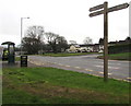
Wooden signpost near Maendy Square, Cwmbran
The Active Travel signpost is alongside Maendy Way. The Torfaen County Borough website states that in September 2014, the Welsh Government introduced the Active Travel (Wales) Act 2013 which places a legal requirement on local authorities in Wales to map, plan, improve and promote routes deemed suitable for active travel. Active travel means walking and cycling for everyday short-distance journeys, such as journeys to school, work, or for access to shops or services. Active travel does not include journeys purely made for recreation or social reasons.
Image: © Jaggery
Taken: 29 Mar 2017
0.08 miles
9
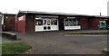
Jessica's Boutique, West Pontnewydd, Cwmbran
At the western end of Maendy Square shops.
Image: © Jaggery
Taken: 29 Mar 2017
0.09 miles
10
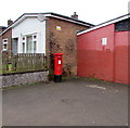
Queen Elizabeth II pillarbox, Maendy Square, West Pontnewydd, Cwmbran
On the left here. http://www.geograph.org.uk/photo/5329263
Image: © Jaggery
Taken: 29 Mar 2017
0.09 miles