IMAGES TAKEN NEAR TO
Maendy Way, CWMBRAN, NP44 5HP
Introduction
This page details the photographs taken nearby to Maendy Way, NP44 5HP by members of the Geograph project.
The Geograph project started in 2005 with the aim of publishing, organising and preserving representative images for every square kilometre of Great Britain, Ireland and the Isle of Man.

There are currently over 7.5m images from over14,400 individuals and you can help contribute to the project by visiting https://www.geograph.org.uk
Image Map
Images are licensed for reuse under creativecommons.org/licenses/by-sa/2.0
Notes
- Clicking on the map will re-center to the selected point.
- The higher the marker number, the further away the image location is from the centre of the postcode.
Image Listing (72 Images Found)
Images are licensed for reuse under creativecommons.org/licenses/by-sa/2.0
Image
Details
Distance
1
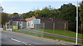
Upper Cwmbran Community Education Centre & Advisory Centre
Located on Upper Cwmbran Road.
Image: © Jaggery
Taken: 17 Oct 2009
0.01 miles
2
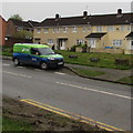
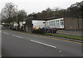
SSE van, Maendy Way, Cwmbran
SSE plc (formerly Scottish and Southern Energy plc) is an energy company based in Perth, Scotland.
Image: © Jaggery
Taken: 29 Mar 2017
0.01 miles
3
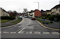
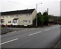
Northern end of Maendy Way, Upper Cwmbran
South along Maendy Way from Upper Cwmbran Road.
Image: © Jaggery
Taken: 29 Mar 2017
0.02 miles
4
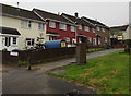
Heol Newydd houses, Upper Cwmbran
On the west side of Maendy Way, opposite the Mynydd Maen Road junction.
Image: © Jaggery
Taken: 29 Mar 2017
0.04 miles
5
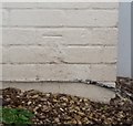
Ordnance Survey Cut Mark
This OS cut mark can be found on No1 Heol Newydd. It marks a point 136.602m above mean sea level.
Image: © Adrian Dust
Taken: 17 Aug 2020
0.04 miles
6
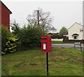
Queen Elizabeth II postbox on an Upper Cwmbran corner
Located on the right here, http://www.geograph.org.uk/photo/5329366 on the corner of Mynydd Maen Road and Maendy Way.
Image: © Jaggery
Taken: 29 Mar 2017
0.04 miles
7
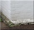
Ordnance Survey Cut Mark
This OS cut mark can be found on the Upper Cwmbran Infant School. It marks a point 133.262m above mean sea level.
Image: © Adrian Dust
Taken: 17 Aug 2020
0.04 miles
8
Nant Bran Centre, Upper Cwmbran
Viewed across Upper Cwmbran Road. Nant Bran Centre for creativity and well-being opened here in the former Upper Cwmbran Infants School in October 2015. The Nant Bran Centre is the base for Able Radio, the local mental health charity CMIG and the regional base for the Alzheimer's Society. The centre has a large space available for hire by community organisations.
Image: © Jaggery
Taken: 29 Mar 2017
0.05 miles
9
Corner of Upper Cwmbran Road and Rhiw Melin, Upper Cwmbran
Houses at the northern end of Rhiw Melin viewed across Upper Cwmbran Road.
Image: © Jaggery
Taken: 29 Mar 2017
0.06 miles
10
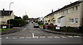
Rhiw Melin, Upper Cwmbran
From Upper Cwmbran Road, the dead end road Rhiw Melin leads to the Hawthorns.
Image: © Jaggery
Taken: 29 Mar 2017
0.06 miles