IMAGES TAKEN NEAR TO
Norfolk Close, CWMBRAN, NP44 5HJ
Introduction
This page details the photographs taken nearby to Norfolk Close, NP44 5HJ by members of the Geograph project.
The Geograph project started in 2005 with the aim of publishing, organising and preserving representative images for every square kilometre of Great Britain, Ireland and the Isle of Man.

There are currently over 7.5m images from over14,400 individuals and you can help contribute to the project by visiting https://www.geograph.org.uk
Image Map
Images are licensed for reuse under creativecommons.org/licenses/by-sa/2.0
Notes
- Clicking on the map will re-center to the selected point.
- The higher the marker number, the further away the image location is from the centre of the postcode.
Image Listing (57 Images Found)
Images are licensed for reuse under creativecommons.org/licenses/by-sa/2.0
Image
Details
Distance
1
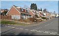
Wellington Drive, Greenmeadow, Cwmbran
Houses on the west side of Wellington Drive, viewed from Marlborough Road.
Image: © Jaggery
Taken: 30 Jan 2011
0.03 miles
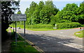
2
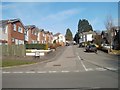
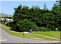
Norfolk Close, Greenmeadow, Cwmbran
Viewed from Marlborough Road.
Image: © Jaggery
Taken: 30 Jan 2011
0.03 miles
3
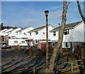
Bedford Close, Greenmeadow, Cwmbran
Viewed from the edge of a Ty Gwyn Road footbridge.
Image: © Jaggery
Taken: 30 Jan 2011
0.04 miles
4
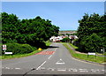
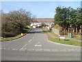
Marlborough Road, Greenmeadow, Cwmbran
Marlborough Road ascends from the Ty Gwyn Way junction.
The right turn ahead is the Wellington Drive junction.
Image: © Jaggery
Taken: 30 May 2016
0.04 miles
5
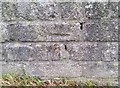
Ordnance Survey Cut Mark
This OS cut mark can be found on the wall NE side of Marlborough Road. It marks a point 150.080m above mean sea level.
Image: © Adrian Dust
Taken: 17 Aug 2020
0.06 miles
6
Two telecoms cabinets on a Greenmeadow corner, Cwmbran
On the corner of Ty Gwyn Way and Marlborough Road.
A Virgin Media cabinet is a few metres left of an Openreach/BT cabinet.
Image: © Jaggery
Taken: 30 May 2016
0.07 miles
7
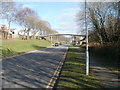
Marlborough Road, Greenmeadow, Cwmbran
Marlborough Road heads away from the junction with Ty Gwyn Way.
Image: © Jaggery
Taken: 30 Jan 2011
0.07 miles
8
Footbridge from Bedford Close to Barnets, Cwmbran
The footbridge above Ty Gwyn Road connects Bedford Close http://www.geograph.org.uk/photo/2287235 on the left with a group of houses on the right in Barnets.
Image: © Jaggery
Taken: 30 Jan 2011
0.08 miles
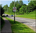
9
Next left for Fairwater Leisure Centre, Cwmbran
The direction sign faces Ty Gwyn Way in the Greenmeadow area of Cwmbran.
The Marlborough Road junction http://www.geograph.org.uk/photo/5336845 is on the right.
Image: © Jaggery
Taken: 30 May 2016
0.08 miles
10
Warning sign - School, Greenmeadow, Cwmbran
Facing Ty Gwyn Way on the approach to Greenmeadow Primary School.
Image: © Jaggery
Taken: 30 May 2016
0.09 miles