1
Ordnance Survey Cut Mark
This OS cut mark can be found on the wall at the Bus Layby, Ty Gwyn Road. It marks a point 150.720m above mean sea level.
Image: © Adrian Dust
Taken: 17 Aug 2020
0.10 miles
2
Queen Elizabeth II pillarbox, Ty Gwyn Way, Greenmeadow, Cwmbran
Located here. http://www.geograph.org.uk/photo/5336998
Image: © Jaggery
Taken: 30 May 2016
0.10 miles
3
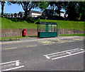
Bus shelter and pillarbox in Greenmeadow, Cwmbran
Alongside a Ty Gwyn Way bus stop in the Greenmeadow area of Cwmbran.
Image: © Jaggery
Taken: 30 May 2016
0.11 miles
4
Junction of Ty Gwyn Road and Ty Gwyn Way, Cwmbran
Looking along Ty Gwyn Road towards the T-junction with Ty Gwyn Way.
Image: © Jaggery
Taken: 30 Jan 2011
0.11 miles
5
Green Meadow Farm
This is the old farm house. Visitors can pet and feed the animals. A lovely day out for all the family.
Image: © Gale Jolly
Taken: 11 Jul 2005
0.11 miles
6
Northern end of Marlborough Road, Cwmbran
The view north towards houses at the top end of Marlborough Road. Behind the houses is Greenmeadow Wood.
Image: © Jaggery
Taken: 30 Jan 2011
0.12 miles
7
Path from Ty Gwyn Road to Ty Gwyn Way, Cwmbran
Giving walkers a shortcut.
Image: © Jaggery
Taken: 30 May 2016
0.12 miles
8
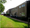
Beddick houses, Greenmeadow, Cwmbran
Beddick is a cul-de-sac on the south side of Ty Gwyn Way.
Image: © Jaggery
Taken: 30 May 2016
0.12 miles
9
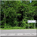
Directions sign, Ty Gwyn Way, Cwmbran
Facing the Ty Gwyn Road junction. Left for Fairwater and Coed Eva, right for Thornhill and the town centre (canol y dref in Welsh). The trees are at the edge of Greenmeadow Wood.
Image: © Jaggery
Taken: 30 May 2016
0.12 miles
10
Ty Gwyn Road, Cwmbran, NE of a footbridge
The view NE from a footbridge. http://www.geograph.org.uk/photo/2287253
Houses on the right are in Beddick and Barnets, examples of the single-word road names prevalent in this area. Other examples are Woolpitch, http://www.geograph.org.uk/photo/2287194 Bowleaze and Charston.
Image: © Jaggery
Taken: 30 Jan 2011
0.13 miles


