IMAGES TAKEN NEAR TO
Spring Grove, CWMBRAN, NP44 5EA
Introduction
This page details the photographs taken nearby to Spring Grove, NP44 5EA by members of the Geograph project.
The Geograph project started in 2005 with the aim of publishing, organising and preserving representative images for every square kilometre of Great Britain, Ireland and the Isle of Man.

There are currently over 7.5m images from over14,400 individuals and you can help contribute to the project by visiting https://www.geograph.org.uk
Image Map
Images are licensed for reuse under creativecommons.org/licenses/by-sa/2.0
Notes
- Clicking on the map will re-center to the selected point.
- The higher the marker number, the further away the image location is from the centre of the postcode.
Image Listing (44 Images Found)
Images are licensed for reuse under creativecommons.org/licenses/by-sa/2.0
Image
Details
Distance
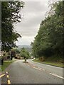
2
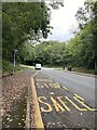
Bus stop - Safle
Bus stop on Ty Canol, Cwmbran.
Image: © Alan Hughes
Taken: 5 Sep 2022
0.04 miles
3
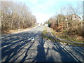
Penmaes Road, Cwmbran
Penmaes Road heads north away from Ty Canol Way.
Image: © Jaggery
Taken: 30 Jan 2011
0.07 miles
4
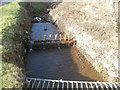
Dowlais Brook, Penmaes Road, Cwmbran
Dowlais Brook flows SE under Penmaes Road, between Rosemead and Beechleigh Close.
Its course ends several kilometres to SE, at its confluence with the Afon Lwyd.
Image: © Jaggery
Taken: 30 Jan 2011
0.10 miles
6
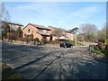
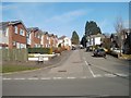
Spring Grove, Cwmbran
The SE edge of Spring Grove, viewed across Ty Canol Way.
Image: © Jaggery
Taken: 30 Jan 2011
0.11 miles
7
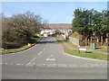
Marlborough Road, Greenmeadow, Cwmbran
Marlborough Road heads away from the junction with Ty Gwyn Way.
Image: © Jaggery
Taken: 30 Jan 2011
0.12 miles
8
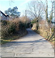
Craig Road, Cwmbran
Viewed from near Ty Canol Way. Craig Road follows a semi-rural route towards the western edge of residential Cwmbran.
Image: © Jaggery
Taken: 30 Jan 2011
0.12 miles
9
Norfolk Close, Greenmeadow, Cwmbran
Viewed from Marlborough Road.
Image: © Jaggery
Taken: 30 Jan 2011
0.14 miles
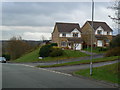
10
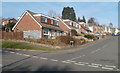
Wellington Drive, Greenmeadow, Cwmbran
Houses on the west side of Wellington Drive, viewed from Marlborough Road.
Image: © Jaggery
Taken: 30 Jan 2011
0.14 miles