IMAGES TAKEN NEAR TO
Springvale Industrial Estate, CWMBRAN, NP44 5BE
Introduction
This page details the photographs taken nearby to Springvale Industrial Estate, NP44 5BE by members of the Geograph project.
The Geograph project started in 2005 with the aim of publishing, organising and preserving representative images for every square kilometre of Great Britain, Ireland and the Isle of Man.

There are currently over 7.5m images from over14,400 individuals and you can help contribute to the project by visiting https://www.geograph.org.uk
Image Map
Images are licensed for reuse under creativecommons.org/licenses/by-sa/2.0
Notes
- Clicking on the map will re-center to the selected point.
- The higher the marker number, the further away the image location is from the centre of the postcode.
Image Listing (21 Images Found)
Images are licensed for reuse under creativecommons.org/licenses/by-sa/2.0
Image
Details
Distance
1
Units 93-95, Springvale Industrial Estate, Cwmbran
In increasing distance from the camera are:
Unit 93, Phil James Upholstery.
Unit 94, Crossford Oil & Tool Supplies.
Unit 95, Gwent Wholesale Ltd (trade only).
Image: © Jaggery
Taken: 30 Jan 2011
0.09 miles
2
Fike, Springvale Industrial Estate, Cwmbran
Occupying unit 31, Fike Safety Technology's product range includes intelligent smoke detectors, sounders, manual call points and control panels.
Image: © Jaggery
Taken: 30 Jan 2011
0.13 miles
3
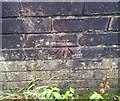
Ordnance Survey Cut Mark
This OS cut mark can be found on the wall of No10 Green Forge Way. It marks a point 85.960m above mean sea level.
Image: © Adrian Dust
Taken: 17 Aug 2020
0.17 miles
4
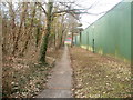
Footpath between Greenforge Way and Springvale Industrial Estate, Cwmbran
There is no roadside pavement on the north side of Greenforge Way in this area. Instead, pedestrians use this path, a few metres from the roadway.
Image: © Jaggery
Taken: 30 Jan 2011
0.17 miles
5
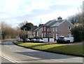
Small group of houses, Greenforge Way, Cwmbran
This section of Greenforge Way is one of contrasts. On the north side of the road is Springvale Industrial Estate. http://www.geograph.org.uk/photo/2254437
On the south side, there are a few scattered groups of houses in a semi-rural setting.
Image: © Jaggery
Taken: 30 Jan 2011
0.18 miles
6
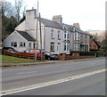
Greenforge Way houses, Cwmbran
In contrast with the south side of Greenforge Way, the location of Springvale Industrial Estate, the north side is semi-rural with only a few houses amongst fields and trees.
These houses are to the west of Woodland Street. http://www.geograph.org.uk/photo/2254391
Image: © Jaggery
Taken: 30 Jan 2011
0.22 miles
7
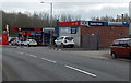
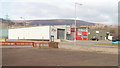
Colley Motors, Cwmbran
Car sales business and Texaco filling station viewed across Maendy Way.
Image: © Jaggery
Taken: 9 Apr 2014
0.22 miles
8
Two industrial units and an eco unit, Springvale Industrial Estate, Cwmbran
Viewed across Greenforge Way. Alongside units 5 and 6 is an eco unit http://www.geograph.org.uk/photo/1088775 with solar panel.
Image: © Jaggery
Taken: 30 Jan 2011
0.23 miles
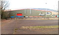
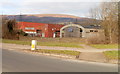
10
Maendy Way leading to industrial buildings
Image: © David Smith
Taken: 29 Sep 2021
0.23 miles