IMAGES TAKEN NEAR TO
Springvale Industrial Estate, CWMBRAN, NP44 5AZ
Introduction
This page details the photographs taken nearby to Springvale Industrial Estate, NP44 5AZ by members of the Geograph project.
The Geograph project started in 2005 with the aim of publishing, organising and preserving representative images for every square kilometre of Great Britain, Ireland and the Isle of Man.

There are currently over 7.5m images from over14,400 individuals and you can help contribute to the project by visiting https://www.geograph.org.uk
Image Map
Images are licensed for reuse under creativecommons.org/licenses/by-sa/2.0
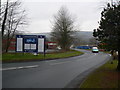
Notes
- Clicking on the map will re-center to the selected point.
- The higher the marker number, the further away the image location is from the centre of the postcode.
Image Listing (157 Images Found)
Images are licensed for reuse under creativecommons.org/licenses/by-sa/2.0
Image
Details
Distance
1
Springvale Industrial Estate in Cwmbran
Image: © Colin Madge
Taken: 23 Dec 2008
0.01 miles
2
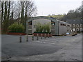
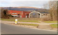
Eco building in Cwmbran
Torfaen County Borough Council-owned green facility building on the Springvale Industrial Estate in Cwmbran.
Greener business practices pioneered at Torfaen’s most environmentally friendly building are being hailed as a great example for businesses and communities throughout Wales.
Image: © Colin Madge
Taken: 23 Dec 2008
0.03 miles
3
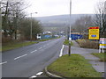
Main road in Springvale Industrial Estate
Favourite for local driving schools
Image: © Colin Madge
Taken: 23 Dec 2008
0.03 miles
4
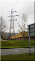
Pylon, Springvale Industrial Estate, Cwmbran
The pylon is located between Springvale Way (in the foreground) and Woodside Way (directly behind the pylon).
Image: © Jaggery
Taken: 3 Apr 2010
0.05 miles
5
Two industrial units and an eco unit, Springvale Industrial Estate, Cwmbran
Viewed across Greenforge Way. Alongside units 5 and 6 is an eco unit http://www.geograph.org.uk/photo/1088775 with solar panel.
Image: © Jaggery
Taken: 30 Jan 2011
0.05 miles
6
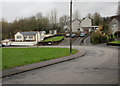
Greenforge Way at Woodland Street junction - with view
Among the retail parks, industrial estates and many roundabouts are some older houses, such as those in this picture. And here, close to the Valleys of South Wales, you're never far from a wonderful view.
Image: © Ruth Sharville
Taken: 1 Jun 2007
0.06 miles
7
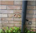
Ordnance Survey Cut Mark
This OS cut mark can be found on No107 Springvale Industrial Estate. It marks a point 82.350m above mean sea level.
Image: © Adrian Dust
Taken: 17 Aug 2020
0.06 miles
8
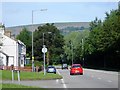
Cwmbran : Greenforge Way approaches Springvale roundabout
Ahead, at an elongated roundabout, is the entrance road to Springvale Industrial Estate.
Image: © Jaggery
Taken: 30 Jan 2011
0.08 miles
9
Greenhill Road, Forge Hammer, Cwmbran
Houses at the far end of Greenhill Road.
Image: © Jaggery
Taken: 3 Apr 2010
0.09 miles
10
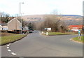
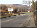
Edge of Springvale roundabout, Cwmbran
Right for Springvale Industrial Estate, ahead along Greenforge Way for Greenmeadow (¾), Thornhill (1), Ty canol (1½), Fairwater (1) and the Community Farm (½). All distances in miles. The houses are on Woodland Street. http://www.geograph.org.uk/photo/2254391
Image: © Jaggery
Taken: 30 Jan 2011
0.09 miles