IMAGES TAKEN NEAR TO
Upper Cwmbran, CWMBRAN, NP44 5AU
Introduction
This page details the photographs taken nearby to NP44 5AU by members of the Geograph project.
The Geograph project started in 2005 with the aim of publishing, organising and preserving representative images for every square kilometre of Great Britain, Ireland and the Isle of Man.

There are currently over 7.5m images from over14,400 individuals and you can help contribute to the project by visiting https://www.geograph.org.uk
Image Map
Images are licensed for reuse under creativecommons.org/licenses/by-sa/2.0
Notes
- Clicking on the map will re-center to the selected point.
- The higher the marker number, the further away the image location is from the centre of the postcode.
Image Listing (24 Images Found)
Images are licensed for reuse under creativecommons.org/licenses/by-sa/2.0
Image
Details
Distance
1
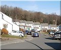
Monnow Court houses, Cwmbran
Viewed across Graig Road.
Image: © Jaggery
Taken: 30 Jan 2011
0.04 miles
2
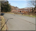
Say it with boulders, Graig Road, Cwmbran
A sign stating 'No vehicles beyond this point' is not needed here - boulders are better, as they cannot be ignored.
Image: © Jaggery
Taken: 30 Jan 2011
0.04 miles
3
Northern end of Marlborough Road, Cwmbran
The view north towards houses at the top end of Marlborough Road. Behind the houses is Greenmeadow Wood.
Image: © Jaggery
Taken: 30 Jan 2011
0.13 miles
4
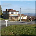
Monnow Court, Thornhill, Cwmbran
The cul-de-sac Monnow Court is an extensive area of houses above Hafren Road
at the western edge of the Thornhill district of Cwmbran.
Image: © Jaggery
Taken: 6 Apr 2017
0.14 miles
5
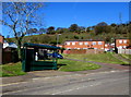
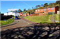
Monnow Court bus stop and shelter, Thornhill, Cwmbran
The bus stop is alongside Hafren Road near the corner of Monnow Court.
In early April 2017, the stop is on Stagecoach bus route 1 from Cwmbran to Thornhill.
Image: © Jaggery
Taken: 6 Apr 2017
0.17 miles
6
Western edge of Oaklands View, Cwmbran
Viewed from Penmaes Road.
Image: © Jaggery
Taken: 30 Jan 2011
0.17 miles
7
Thornhill electricity substation, Cwmbran
The Western Power Distribution electricity substation is set back from Hafren Road near Stour Court.
Its identifier is THORNHILL CWMBRAN S/S No. 53-1954.
Image: © Jaggery
Taken: 6 Apr 2017
0.18 miles
8
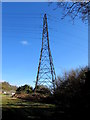
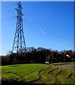
Electricity pylon near Hafren Road, Thornhill, Cwmbran
Set back from Hafren Road near the Monnow Court junction.
The Western Power Distribution identifier on the pylon is LE3.
Image: © Jaggery
Taken: 6 Apr 2017
0.18 miles
9
Electricity pylon in Thornhill, Cwmbran
Set back from Hafren Road near the Monnow Court junction.
The Western Power Distribution identifier on the pylon is LE3.
Image: © Jaggery
Taken: 6 Apr 2017
0.18 miles
10
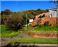
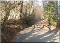
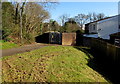
Path to Rhymney Court, Thornhill, Cwmbran
From Hafren Road to the southern edge of houses in Rhymney Court.
Image: © Jaggery
Taken: 6 Apr 2017
0.19 miles