IMAGES TAKEN NEAR TO
Graig Road, CWMBRAN, NP44 5AS
Introduction
This page details the photographs taken nearby to Graig Road, NP44 5AS by members of the Geograph project.
The Geograph project started in 2005 with the aim of publishing, organising and preserving representative images for every square kilometre of Great Britain, Ireland and the Isle of Man.

There are currently over 7.5m images from over14,400 individuals and you can help contribute to the project by visiting https://www.geograph.org.uk
Image Map
Images are licensed for reuse under creativecommons.org/licenses/by-sa/2.0
Notes
- Clicking on the map will re-center to the selected point.
- The higher the marker number, the further away the image location is from the centre of the postcode.
Image Listing (47 Images Found)
Images are licensed for reuse under creativecommons.org/licenses/by-sa/2.0
Image
Details
Distance
2
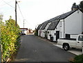
Graig View, Upper Cwmbran
Graig View is a group of interestingly-roofed houses on Tram Road.
Image: © Jaggery
Taken: 17 Oct 2009
0.14 miles
3
Belle Vue Lane, Upper Cwmbran
Such an insignificant lane, it seems, that neither the OS online maps, nor the local A-Z Street Atlas, bothers to name it.
Image: © Jaggery
Taken: 17 Oct 2009
0.15 miles
4
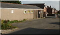
School entrance path, Upper Cwmbran
From Thornhill Road towards Woodlands Community Primary School and Integrated Children's Centre.
Image: © Jaggery
Taken: 29 Mar 2017
0.16 miles
5
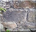
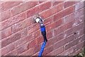
Ordnance Survey Cut Mark
This OS cut mark can be found on the wall of Penywaun Farm. It marks a point 167.872m above mean sea level.
Image: © Adrian Dust
Taken: 17 Aug 2020
0.17 miles
6
Graig Vue Hall, Upper Cwmbran
Graig Vue (so spelt) Hall is located on Tram Road, close to Graig View http://www.geograph.org.uk/photo/1639523. Meeting place for Upper Cwmbran Old Age Pensioners Club.
Image: © Jaggery
Taken: 17 Oct 2009
0.17 miles
7

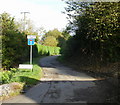
Kissing gate to a track on the SE side of The Square, Upper Cwmbran
The track heads towards Belle Vue Lane.
Image: © Jaggery
Taken: 7 Jan 2012
0.18 miles
8
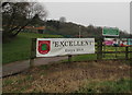
Woodlands School Excellent banner facing Thornhill Road, Upper Cwmbran
After the Estyn inspection in early 2014, Woodlands Community Primary School's performance and future prospects were both classed as excellent.
The name sign on the right shows Woodlands Community Primary School and Integrated Children's Centre.
Image: © Jaggery
Taken: 29 Mar 2017
0.18 miles
9
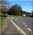
Thornhill Road bus stop and shelter, Upper Cwmbran
The stop is on Stagecoach bus route 1 from Thornhill to Cwmbran bus station.
Image: © Jaggery
Taken: 6 Apr 2017
0.18 miles
10
Ordnance Survey Cut Mark
This OS cut mark can be found on No31 Bagley Court. It marks a point 163.170m above mean sea level.
Image: © Adrian Dust
Taken: 17 Aug 2020
0.18 miles