IMAGES TAKEN NEAR TO
Tram Road, CWMBRAN, NP44 5AD
Introduction
This page details the photographs taken nearby to Tram Road, NP44 5AD by members of the Geograph project.
The Geograph project started in 2005 with the aim of publishing, organising and preserving representative images for every square kilometre of Great Britain, Ireland and the Isle of Man.

There are currently over 7.5m images from over14,400 individuals and you can help contribute to the project by visiting https://www.geograph.org.uk
Image Map
Images are licensed for reuse under creativecommons.org/licenses/by-sa/2.0
Notes
- Clicking on the map will re-center to the selected point.
- The higher the marker number, the further away the image location is from the centre of the postcode.
Image Listing (59 Images Found)
Images are licensed for reuse under creativecommons.org/licenses/by-sa/2.0
Image
Details
Distance
1
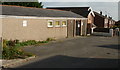
Graig Vue Hall, Upper Cwmbran
Graig Vue (so spelt) Hall is located on Tram Road, close to Graig View http://www.geograph.org.uk/photo/1639523. Meeting place for Upper Cwmbran Old Age Pensioners Club.
Image: © Jaggery
Taken: 17 Oct 2009
0.01 miles
2
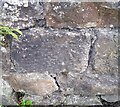
Ordnance Survey Cut Mark
This OS cut mark can be found on the wall of Penywaun Farm. It marks a point 167.872m above mean sea level.
Image: © Adrian Dust
Taken: 17 Aug 2020
0.04 miles
3
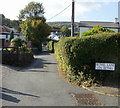
Bethel Lane, Upper Cwmbran
From Upper Cwmbran Road.
Image: © Jaggery
Taken: 17 Oct 2009
0.05 miles
4
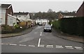
Thornhill Close, Upper Cwmbran
Ascending from Thornhill Road.
Image: © Jaggery
Taken: 29 Mar 2017
0.05 miles
5
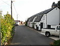
Graig View, Upper Cwmbran
Graig View is a group of interestingly-roofed houses on Tram Road.
Image: © Jaggery
Taken: 17 Oct 2009
0.06 miles
6
Tram Road, Upper Cwmbran
Looking along Tram Road from the corner of Graig Road.
Image: © Jaggery
Taken: 17 Oct 2009
0.08 miles
7
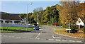
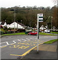
Upper Cwmbran Road
Upper Cwmbran Road, from the lower right of the photo, here makes a right turn. The road continuing on the left is Thornhill Road.
Image: © Jaggery
Taken: 17 Oct 2009
0.08 miles
8
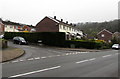
Long hedge on an Upper Cwmbran corner
On the corner of Thornhill Road and Thornhill Close.
Image: © Jaggery
Taken: 29 Mar 2017
0.08 miles
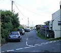
9
Playing Fields bus stop, Thornhill Road, Upper Cwmbran
In late March 2017, the information board on the pole shows that this is a stop on Stagecoach bus route number 1 from Cwmbran bus station. This stop is not a timing point so the times shown on the board are estimates.
Image: © Jaggery
Taken: 29 Mar 2017
0.09 miles
10
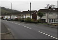
Thornhill Road semis, Upper Cwmbran
Semi-detached houses on the east side of Thornhill Road, north of Sycamore Place.
Image: © Jaggery
Taken: 29 Mar 2017
0.10 miles