IMAGES TAKEN NEAR TO
Barnets, CWMBRAN, NP44 4UZ
Introduction
This page details the photographs taken nearby to Barnets, NP44 4UZ by members of the Geograph project.
The Geograph project started in 2005 with the aim of publishing, organising and preserving representative images for every square kilometre of Great Britain, Ireland and the Isle of Man.

There are currently over 7.5m images from over14,400 individuals and you can help contribute to the project by visiting https://www.geograph.org.uk
Image Map
Images are licensed for reuse under creativecommons.org/licenses/by-sa/2.0
Notes
- Clicking on the map will re-center to the selected point.
- The higher the marker number, the further away the image location is from the centre of the postcode.
Image Listing (86 Images Found)
Images are licensed for reuse under creativecommons.org/licenses/by-sa/2.0
Image
Details
Distance
1
Beddick, Greenmeadow, Cwmbran
Beddick is a cul-de-sac extending for 60 metres from Ty Gwyn Way.
Image: © Jaggery
Taken: 30 May 2016
0.03 miles
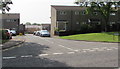
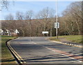
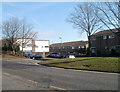
2
Junction of Ty Gwyn Way and Barnets, Greenmeadow, Cwmbran
Viewed across Ty Gwyn Way. The cul-de-sac named Barnets extends ahead for 170 metres.
Image: © Jaggery
Taken: 30 May 2016
0.03 miles
3
Beddick houses, Greenmeadow, Cwmbran
Beddick is a cul-de-sac on the south side of Ty Gwyn Way.
Image: © Jaggery
Taken: 30 May 2016
0.05 miles
4
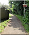
Illegal to ride motor vehicles on this path near Beddick, Cwmbran
The red and white notice states that it is illegal to ride motor vehicles in this area.
Offenders are liable to prosecution. The text is also in Welsh.
Image: © Jaggery
Taken: 30 May 2016
0.06 miles
5
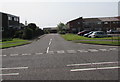
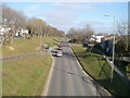
Junction of Ty Gwyn Road and Ty Gwyn Way, Cwmbran
Looking along Ty Gwyn Road towards the T-junction with Ty Gwyn Way.
Image: © Jaggery
Taken: 30 Jan 2011
0.07 miles
6
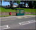
Bus shelter and pillarbox in Greenmeadow, Cwmbran
Alongside a Ty Gwyn Way bus stop in the Greenmeadow area of Cwmbran.
Image: © Jaggery
Taken: 30 May 2016
0.07 miles
7
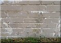
Ordnance Survey Cut Mark
This OS cut mark can be found on the wall at the Bus Layby, Ty Gwyn Road. It marks a point 150.720m above mean sea level.
Image: © Adrian Dust
Taken: 17 Aug 2020
0.07 miles
8
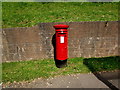
Queen Elizabeth II pillarbox, Ty Gwyn Way, Greenmeadow, Cwmbran
Located here. http://www.geograph.org.uk/photo/5336998
Image: © Jaggery
Taken: 30 May 2016
0.07 miles
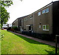
9
Beddick, Greenmeadow, Cwmbran
Houses on the corner of Ty Gwyn Way and Beddick, a road containing 18 houses.
Image: © Jaggery
Taken: 30 Jan 2011
0.08 miles
10
Ty Gwyn Road, Cwmbran, NE of a footbridge
The view NE from a footbridge. http://www.geograph.org.uk/photo/2287253
Houses on the right are in Beddick and Barnets, examples of the single-word road names prevalent in this area. Other examples are Woolpitch, http://www.geograph.org.uk/photo/2287194 Bowleaze and Charston.
Image: © Jaggery
Taken: 30 Jan 2011
0.08 miles