1
Corner of Oxtens and Henllys Way, Coed Eva, Cwmbran
Viewed across Henllys Way. Oxtens is one of several streets in Coed Eva with unusual, one-word names. Other examples are Stiels, Tydies, Stevelee and Willins.
Image: © Jaggery
Taken: 9 Oct 2011
0.05 miles
2
Penylan Way houses, Cwmbran
Penylan Way houses were built with flat roofs, as on the house on the left. Most of the houses have had sloping roofs added, as on the house on the right.
Image: © Jaggery
Taken: 25 Dec 2011
0.06 miles
3
Footbridge across a stream near Henllys Way, Cwmbran
The footbridge gives pedestrians a short cut from Coed Eva and Hollybush Community Hall, http://www.geograph.org.uk/photo/2742133 to Henllys Way across a stream named Nant y milwr.
Image: © Jaggery
Taken: 25 Dec 2011
0.07 miles
4
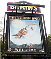
Pub sign, The Blinkin' Owl, Coed Eva, Cwmbran
The owl looks more snoozin' than blinkin'. The pub http://www.geograph.org.uk/photo/2640334 is on the corner of Oxtens and Henllys Way.
Image: © Jaggery
Taken: 9 Oct 2011
0.07 miles
5
The Blinkin' Owl, Coed Eva, Cwmbran
A Brains pub located on the SW corner of Oxtens and Henllys Way. The pub's website describes The Blinkin' Owl as a 'modern community pub'.
Image: © Jaggery
Taken: 9 Oct 2011
0.07 miles
6
The Blinkin' Owl, Coed Eva, Cwmbran
Pub on the corner of Oxtens and Henllys Way.
Image: © Jaggery
Taken: 8 Apr 2010
0.07 miles
7
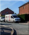
Fitzgerald Plant Services van, Pentre Close, Cwmbran
Text on the van in May 2023 includes "Rail & Construction Equipment Services".
Image: © Jaggery
Taken: 27 May 2023
0.11 miles
8
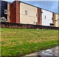
Housing with small windows, Coed Eva, Cwmbran
Viewed from Henllys Way.
Image: © Jaggery
Taken: 31 Dec 2023
0.11 miles
9
Hollybush Way footbridge, Cwmbran
Located near the western end of Hollybush Way, near the roundabout at the Henllys Way junction.
Image: © Jaggery
Taken: 25 Dec 2011
0.13 miles
10
Coed Eva and Hollybush Community Hall, Cwmbran
Viewed from a Hollybush Way footbridge. http://www.geograph.org.uk/photo/2742067
The community hall, known locally as The White Hut, is near the roundabout at the junction of Henllys Way and Hollybush Way. A wide variety of regular weekly activities takes place here. The hall is available for private function hire.
Image: © Jaggery
Taken: 25 Dec 2011
0.13 miles


