IMAGES TAKEN NEAR TO
Deer Brook, CWMBRAN, NP44 4SX
Introduction
This page details the photographs taken nearby to Deer Brook, NP44 4SX by members of the Geograph project.
The Geograph project started in 2005 with the aim of publishing, organising and preserving representative images for every square kilometre of Great Britain, Ireland and the Isle of Man.

There are currently over 7.5m images from over14,400 individuals and you can help contribute to the project by visiting https://www.geograph.org.uk
Image Map
Images are licensed for reuse under creativecommons.org/licenses/by-sa/2.0
Notes
- Clicking on the map will re-center to the selected point.
- The higher the marker number, the further away the image location is from the centre of the postcode.
Image Listing (94 Images Found)
Images are licensed for reuse under creativecommons.org/licenses/by-sa/2.0
Image
Details
Distance
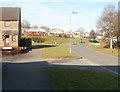
1

Up Byways, Greenmeadow, Cwmbran
The road named Byways ascends from Fairhill towards the Threepenny Bit Community Centre. http://www.geograph.org.uk/photo/5151535
A warning sign shows Humps for 600 yards. The trees are alongside Dowlais Brook.
Image: © Jaggery
Taken: 10 Oct 2016
0.03 miles
2
Fairhill, Cwmbran
The view north up Fairhill. On the left is the edge of St Peter's Close. The houses in the distance are part of Byways, which follows a pattern in this area of streets with one-word names. See http://www.geograph.org.uk/photo/2287265 for other examples.
Image: © Jaggery
Taken: 30 Jan 2011
0.04 miles
3
Fairhill Methodist Church, Cwmbran
Located on the east side of a road named Fairhill, facing houses on Byways. The church was built in the mid 1960s.
It may look like the bus stops are ideally placed for those attending Sunday services here, but the reality is that Stagecoach, the major provider of bus services in Cwmbran, do not run any local buses in the town on Sundays. The only buses currently seen in Cwmbran on Sundays are those on long-distance routes passing through the town, such as Newport to Pontypool and Blaenavon.
Image: © Jaggery
Taken: 30 Jan 2011
0.04 miles
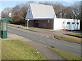
4
Threepenny Bit Community Centre, Greenmeadow, Cwmbran
Located above Dowlais Brook, alongside the road named Byways, this building is the home of CoStar, an independent local charity. Formed in 2000 by a small group of residents with a passion to help and develop their community, CoStar was originally located at Blenheim shops. It moved to the Threepenny Bit Community Centre in 2012. CoStar is involved in a wide range of projects, events and activities aimed at developing and supporting the Cwmbran communities of Greenmeadow, Fairwater, St Dials, Coed Eva and Upper Cwmbran.
Image: © Jaggery
Taken: 10 Oct 2016
0.05 miles
5

Footpath between two underpasses, Greenmeadow, Cwmbran
From the Fairhill underpass towards the Byways underpass.
Image: © Jaggery
Taken: 10 Oct 2016
0.06 miles
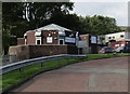
6

Large street name sign on a Greenmeadow corner, Cwmbran
At the junction of Fairhill and Byways, the sign on the right here http://www.geograph.org.uk/photo/5151538 shows Byways and seven side streets to which Byways leads. This is an English-only sign in Cwmbran where most signs are bilingual (English/Welsh).
Image: © Jaggery
Taken: 10 Oct 2016
0.07 miles
7
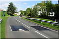
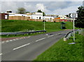
Fairhill speed bumps, Greenmeadow, Cwmbran
The dark grey bumps on Fairhill are on top of a footpath underpass bridge.
The Methodist Church at Fairhill http://www.geograph.org.uk/photo/5150880 is behind the trees on the right.
Image: © Jaggery
Taken: 10 Oct 2016
0.07 miles
8
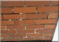
Ordnance Survey Cut Mark
This OS cut mark can be found on the west angle of Fairhill Church. It marks a point 109.870m above mean sea level.
Image: © Adrian Dust
Taken: 17 Aug 2020
0.07 miles
9
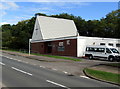
The Methodist Church at Fairhill, Greenmeadow, Cwmbran
Built in the mid 1960s, the Methodist Church at Fairhill is part of the Gwent Hills & Vales Methodist Circuit.
In October 2016, the Sunday Service starts at 10:55am.
Image: © Jaggery
Taken: 10 Oct 2016
0.07 miles
10
Bilingual direction sign, Greenmeadow, Cwmbran
Showing Shop and the Welsh Siop, the sign alongside Fairhill points towards Byways. http://www.geograph.org.uk/photo/5151538
Image: © Jaggery
Taken: 10 Oct 2016
0.08 miles