IMAGES TAKEN NEAR TO
Holmdale, CWMBRAN, NP44 4SP
Introduction
This page details the photographs taken nearby to Holmdale, NP44 4SP by members of the Geograph project.
The Geograph project started in 2005 with the aim of publishing, organising and preserving representative images for every square kilometre of Great Britain, Ireland and the Isle of Man.

There are currently over 7.5m images from over14,400 individuals and you can help contribute to the project by visiting https://www.geograph.org.uk
Image Map
Images are licensed for reuse under creativecommons.org/licenses/by-sa/2.0
Notes
- Clicking on the map will re-center to the selected point.
- The higher the marker number, the further away the image location is from the centre of the postcode.
Image Listing (93 Images Found)
Images are licensed for reuse under creativecommons.org/licenses/by-sa/2.0
Image
Details
Distance
1

Warning sign - Patrol/Hebryngwr, Fairhill, Greenmeadow, Cwmbran
The bilingual (English/Welsh) sign faces Fairhill in the Greenmeadow area of Cwmbran.
The Stagecoach bus is on Route 5 to Cwmbran bus station.
Image: © Jaggery
Taken: 10 Oct 2016
0.02 miles
2
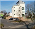
Maybury House, Cwmbran
5-storey block of flats on the corner of Fairhill and Byways in the Greenmeadow area of Cwmbran.
Image: © Jaggery
Taken: 30 Jan 2011
0.03 miles
3

Ellwood Path, Greenmeadow, Cwmbran
Ellwood Path descends from the south side of Fairhill.
Image: © Jaggery
Taken: 10 Oct 2016
0.05 miles
4

Junction of Fairhill and Byways, Greenmeadow, Cwmbran
Byways ascends from Fairhill. This is one of two junctions of Fairhill and Byways.
The other one http://www.geograph.org.uk/photo/5151538 is 220 metres to the southwest.
Image: © Jaggery
Taken: 10 Oct 2016
0.06 miles
5
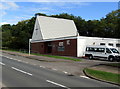
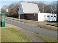
The Methodist Church at Fairhill, Greenmeadow, Cwmbran
Built in the mid 1960s, the Methodist Church at Fairhill is part of the Gwent Hills & Vales Methodist Circuit.
In October 2016, the Sunday Service starts at 10:55am.
Image: © Jaggery
Taken: 10 Oct 2016
0.06 miles
6

Up Byways, Greenmeadow, Cwmbran
The road named Byways ascends from Fairhill towards the Threepenny Bit Community Centre. http://www.geograph.org.uk/photo/5151535
A warning sign shows Humps for 600 yards. The trees are alongside Dowlais Brook.
Image: © Jaggery
Taken: 10 Oct 2016
0.06 miles
7
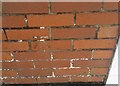
Ordnance Survey Cut Mark
This OS cut mark can be found on the west angle of Fairhill Church. It marks a point 109.870m above mean sea level.
Image: © Adrian Dust
Taken: 17 Aug 2020
0.07 miles
8

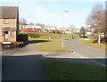
Two bus stops, Fairhill, Greenmeadow, Cwmbran
The stops alongside Fairhill are on Stagecoach Route 5 to and from Cwmbran bus station.
Only the stop on the left has a shelter. The left turn ahead is into Badgers Mede. http://www.geograph.org.uk/photo/5151588
Image: © Jaggery
Taken: 10 Oct 2016
0.08 miles
9
Fairhill, Cwmbran
The view north up Fairhill. On the left is the edge of St Peter's Close. The houses in the distance are part of Byways, which follows a pattern in this area of streets with one-word names. See http://www.geograph.org.uk/photo/2287265 for other examples.
Image: © Jaggery
Taken: 30 Jan 2011
0.08 miles
10
Fairhill Methodist Church, Cwmbran
Located on the east side of a road named Fairhill, facing houses on Byways. The church was built in the mid 1960s.
It may look like the bus stops are ideally placed for those attending Sunday services here, but the reality is that Stagecoach, the major provider of bus services in Cwmbran, do not run any local buses in the town on Sundays. The only buses currently seen in Cwmbran on Sundays are those on long-distance routes passing through the town, such as Newport to Pontypool and Blaenavon.
Image: © Jaggery
Taken: 30 Jan 2011
0.08 miles