IMAGES TAKEN NEAR TO
Cresswell Walk, CWMBRAN, NP44 4RG
Introduction
This page details the photographs taken nearby to Cresswell Walk, NP44 4RG by members of the Geograph project.
The Geograph project started in 2005 with the aim of publishing, organising and preserving representative images for every square kilometre of Great Britain, Ireland and the Isle of Man.

There are currently over 7.5m images from over14,400 individuals and you can help contribute to the project by visiting https://www.geograph.org.uk
Image Map
Images are licensed for reuse under creativecommons.org/licenses/by-sa/2.0
Notes
- Clicking on the map will re-center to the selected point.
- The higher the marker number, the further away the image location is from the centre of the postcode.
Image Listing (91 Images Found)
Images are licensed for reuse under creativecommons.org/licenses/by-sa/2.0
Image
Details
Distance
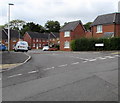
1
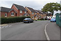
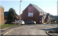
Recently-built houses in St Dials, Cwmbran
Viewed from the corner of Thorncliffe Road in October 2016.
A May 2011 Google Earth Street View shows fenced-off new houses here, looking almost complete externally.
Image: © Jaggery
Taken: 20 Oct 2016
0.03 miles
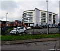
2
Cresswell Walk houses, St Dials, Cwmbran
The Tamarind https://www.geograph.org.uk/photo/7744345 is behind the camera.
Image: © Jaggery
Taken: 7 Apr 2024
0.04 miles
3
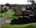
Steps down from Ty Gwyn Road, Greenmeadow, Cwmbran
Steps descend to a path past houses on the east side of Thorncliffe Road.
Image: © Jaggery
Taken: 10 Oct 2016
0.04 miles
4
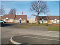
Bungalows, Blenheim Chase, St Dials, Cwmbran
Blenheim Chase is a Lovell development of 1- 2- and 3-bedroom houses adjoining Cresswell Walk, on the southern side of Ty Gwyn Road.
Image: © Jaggery
Taken: 30 Jan 2011
0.05 miles
5
Northern edge of Blenheim Chase, St Dials. Fairwater
Blenheim Chase is a Lovell development of 1- 2- and 3-bedroom houses adjoining Cresswell Walk (at the left edge of the view), on the southern side of Ty Gwyn Road.
Image: © Jaggery
Taken: 30 Jan 2011
0.05 miles
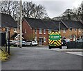
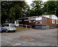
6
Power Station Community Education Centre, St Dials, Cwmbran
Torfaen County Borough Council building set back from Blenheim Road.
Image: © Jaggery
Taken: 20 Oct 2016
0.05 miles
7
Power Station Community Education Centre, St Dials, Cwmbran
Torfaen County Borough Council building set back from Blenheim Road.
Image: © Jaggery
Taken: 20 Oct 2016
0.05 miles
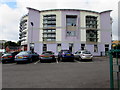
8
St Joseph's Social Club, Blenheim Road, St Dials, Cwmbran
The club's name sign shows the year 1965.
Image: © Jaggery
Taken: 20 Oct 2016
0.06 miles
9
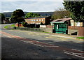
Ty Gwyn Road bus stop and shelter, Greenmeadow, Cwmbran
This side of the road for buses to Cwmbran bus station and the town centre.
Image: © Jaggery
Taken: 10 Oct 2016
0.06 miles
10
Houses at the southeast end of Thorncliffe Road, Cwmbran
Above Blenheim Road, near the Tamarind. http://www.geograph.org.uk/photo/5166883
Image: © Jaggery
Taken: 20 Oct 2016
0.07 miles