IMAGES TAKEN NEAR TO
Fairhill, CWMBRAN, NP44 4RB
Introduction
This page details the photographs taken nearby to Fairhill, NP44 4RB by members of the Geograph project.
The Geograph project started in 2005 with the aim of publishing, organising and preserving representative images for every square kilometre of Great Britain, Ireland and the Isle of Man.

There are currently over 7.5m images from over14,400 individuals and you can help contribute to the project by visiting https://www.geograph.org.uk
Image Map
Images are licensed for reuse under creativecommons.org/licenses/by-sa/2.0
Notes
- Clicking on the map will re-center to the selected point.
- The higher the marker number, the further away the image location is from the centre of the postcode.
Image Listing (97 Images Found)
Images are licensed for reuse under creativecommons.org/licenses/by-sa/2.0
Image
Details
Distance
1
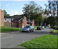
Unnamed side road, Greenmeadow, Cwmbran
Descending from Fairhill, this side road is between houses in
Kingsland Walk on the left and Ellwood Path out of shot on the right.
Image: © Jaggery
Taken: 10 Oct 2016
0.02 miles
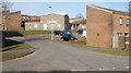
2

Two bus stops, Fairhill, Greenmeadow, Cwmbran
The stops alongside Fairhill are on Stagecoach Route 5 to and from Cwmbran bus station.
Only the stop on the left has a shelter. The left turn ahead is into Badgers Mede. http://www.geograph.org.uk/photo/5151588
Image: © Jaggery
Taken: 10 Oct 2016
0.03 miles
3

Badgers Mede, Greenmeadow, Cwmbran
Badgers Mede is a cul-de-sac on the north side of the road named Fairhill.
An Asda home delivery van is parked in front of lockup garages.
Image: © Jaggery
Taken: 10 Oct 2016
0.03 miles
4
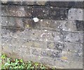
Ordnance Survey Cut Mark
This OS cut mark can be found on the wall of No1 Crofts Corner. It marks a point 114.880m above mean sea level.
Image: © Adrian Dust
Taken: 17 Aug 2020
0.04 miles
5
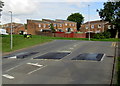
Three speed bumps across Fairhill, Greenmeadow, Cwmbran
Near the northeast end of Fairhill, on the approach to the Ty Gwyn Road junction.
Image: © Jaggery
Taken: 10 Oct 2016
0.04 miles
6

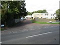
Junction of Fairhill and Byways, Greenmeadow, Cwmbran
Byways ascends from Fairhill. This is one of two junctions of Fairhill and Byways.
The other one http://www.geograph.org.uk/photo/5151538 is 220 metres to the southwest.
Image: © Jaggery
Taken: 10 Oct 2016
0.05 miles
7
Moss Road, Greenmeadow, Cwmbran
Cul-de-sac on the north side of Fairhill.
Image: © Jaggery
Taken: 10 Oct 2016
0.05 miles
8

Ellwood Path, Greenmeadow, Cwmbran
Ellwood Path descends from the south side of Fairhill.
Image: © Jaggery
Taken: 10 Oct 2016
0.06 miles
9
Greenmeadow and St Dials Community Hall, Cwmbran
Viewed from Ty Gwyn Road. The community hall, the central building in the view, is
on a street named Pandy.
Image: © Jaggery
Taken: 30 Jan 2011
0.06 miles
10
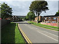
West along Ty Gwyn Road, Greenmeadow, Cwmbran
The left turns are into Thorncliffe Road and Fairhill.
Image: © Jaggery
Taken: 10 Oct 2016
0.06 miles