IMAGES TAKEN NEAR TO
Fairhill Walk, CWMBRAN, NP44 4QY
Introduction
This page details the photographs taken nearby to Fairhill Walk, NP44 4QY by members of the Geograph project.
The Geograph project started in 2005 with the aim of publishing, organising and preserving representative images for every square kilometre of Great Britain, Ireland and the Isle of Man.

There are currently over 7.5m images from over14,400 individuals and you can help contribute to the project by visiting https://www.geograph.org.uk
Image Map
Images are licensed for reuse under creativecommons.org/licenses/by-sa/2.0
Notes
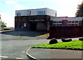
- Clicking on the map will re-center to the selected point.
- The higher the marker number, the further away the image location is from the centre of the postcode.
Image Listing (54 Images Found)
Images are licensed for reuse under creativecommons.org/licenses/by-sa/2.0
Image
Details
Distance
1
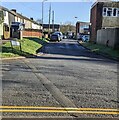
NNE along Fairwater Close, Cwmbran
Cul-de-sac viewed across Ton Road in the Fairwater area of Cwmbran.
Image: © Jaggery
Taken: 30 Mar 2024
0.03 miles
2
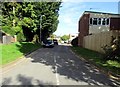
Fairwater Close, Fairwater, Cwmbran
Cul-de-sac viewed from Ton Road.
Image: © Jaggery
Taken: 10 Oct 2016
0.03 miles
3
Telecoms cabinet, Neyland Path, Fairwater, Cwmbran
On the east side of Fairhill.
Image: © Jaggery
Taken: 10 Oct 2016
0.03 miles
4
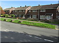
Houses and boulders, Fairhill, Fairwater, Cwmbran
On the east side of Fairhill, viewed from the corner of Ton Road.
Image: © Jaggery
Taken: 10 Oct 2016
0.04 miles
5
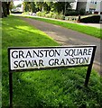
English/Welsh street name sign on a Fairwater corner, Cwmbran
On the corner of Granston Square/Sgwâr Granston and Fairhill/Bryn Tirion.
Image: © Jaggery
Taken: 10 Oct 2016
0.05 miles
6
Cold Calling Control Zone notice, Fairwater, Cwmbran
The Trading Standards Notice faces Fairhill in the Fairwater area of Cwmbran.
See http://www.geograph.org.uk/photo/4325336 for another Cold Calling Control Zone in Torfaen and some details.
Image: © Jaggery
Taken: 10 Oct 2016
0.05 miles
7
Fairhill Walk houses, Fairwater, Cwmbran
Viewed across Fairhill from the corner of Granston Square.
The name plate on the row on the left shows 27-31 Fairhill Walk.
Image: © Jaggery
Taken: 10 Oct 2016
0.06 miles
8
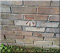
Ordnance Survey Cut Mark
This OS cut mark can be found on No44 Fairhill Walk. It marks a point 103.520m above mean sea level.
Image: © Adrian Dust
Taken: 17 Aug 2020
0.06 miles
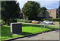
9
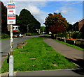
The Spice Inn, Fairwater Square, Cwmbran
Indian restaurant & takeaway viewed in October 2016. The Fairwater House pub was here in April 2010. http://www.geograph.org.uk/photo/1796433
Image: © Jaggery
Taken: 10 Oct 2016
0.07 miles
10
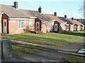
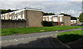
Cheriton Path, Fairwater, Cwmbran
Cheriton Path is a row of six small bungalows, built c1975, located on the east side of Fairhill between Windsor Road and Granston Square.
Image: © Jaggery
Taken: 30 Jan 2011
0.07 miles