1
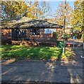
Fairwater Leisure Centre, Cwmbran
Accessed from Ty Gwyn Way, Fairwater Leisure Centre is adjacent to Cwmbran High School.
Image: © Jaggery
Taken: 13 Mar 2022
0.09 miles
2
Fairwater Medical Centre
Set back from the north side of Fairwater Way, on the edge of Fairwater Square shops.
Image: © Jaggery
Taken: 8 Apr 2010
0.10 miles
3
Brunel Road, Fairwater, Cwmbran
Houses built c1970, viewed from the corner of Ty Gwyn Way.
Image: © Jaggery
Taken: 30 Jan 2011
0.10 miles
4
Fairwater Medical Centre, Cwmbran
Names on the single-storey building in November 2021
are Nant Dowlais Health Centre and Fairwater Surgery.
Image: © Jaggery
Taken: 14 Nov 2021
0.11 miles
5
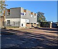
Shared occupancy building, Fairwater, Cwmbran
In November 2021 Well Pets Vets are on the ground floor. The Goodwin Partnership Dental Practice is on the first floor.
Image: © Jaggery
Taken: 14 Nov 2021
0.11 miles
6
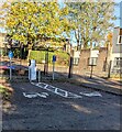
Electric vehicle charging points, Fairwater, Cwmbran
Located near Fairwater Medical Centre. https://www.geograph.org.uk/photo/7021383
Image: © Jaggery
Taken: 14 Nov 2021
0.11 miles
7
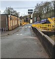
Road to Fairwater Medical Centre, Cwmbran
Viewed from exit from nearby car park.
Image: © M J Roscoe
Taken: 9 Oct 2018
0.12 miles
8
Ordnance Survey Cut Mark
This OS cut mark can be found on a NW face of Ty-gwyn Care Home. It marks a point 114.310m above mean sea level.
Image: © Adrian Dust
Taken: 17 Aug 2020
0.13 miles
9
Bilingual name on a Cwmbran High School building
LOWER BLOCK is BLOC ISAF in Welsh.
Image: © Jaggery
Taken: 13 Mar 2022
0.13 miles
10
Exit road, Fairwater, Cwmbran
This is the exit road from the Cwmbran High School and Fairwater Leisure Centre site.
Turn right ahead for the gentle ascent https://www.geograph.org.uk/photo/7118009 to Ty Gwyn Way.
Image: © Jaggery
Taken: 13 Mar 2022
0.13 miles


