IMAGES TAKEN NEAR TO
Hanley Path, CWMBRAN, NP44 4PD
Introduction
This page details the photographs taken nearby to Hanley Path, NP44 4PD by members of the Geograph project.
The Geograph project started in 2005 with the aim of publishing, organising and preserving representative images for every square kilometre of Great Britain, Ireland and the Isle of Man.

There are currently over 7.5m images from over14,400 individuals and you can help contribute to the project by visiting https://www.geograph.org.uk
Image Map
Images are licensed for reuse under creativecommons.org/licenses/by-sa/2.0
Notes
- Clicking on the map will re-center to the selected point.
- The higher the marker number, the further away the image location is from the centre of the postcode.
Image Listing (102 Images Found)
Images are licensed for reuse under creativecommons.org/licenses/by-sa/2.0
Image
Details
Distance
1
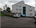
Cranham House, St Dials, Cwmbran
Social housing owned by Bron Afon Housing Association.
Image: © Jaggery
Taken: 20 Oct 2016
0.03 miles
2
Path to Gileston Walk, St Dials, Cwmbran
From a Greenmeadow Way bus stop.
Image: © Jaggery
Taken: 20 Oct 2016
0.07 miles
3
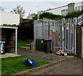
Oakdale Path electricity substation, St Dials, Cwmbran
The Western Power Distribution electricity substation identifier is OAKDALE PATH CWMBRAN S/S No. 531948
Image: © Jaggery
Taken: 20 Oct 2016
0.07 miles
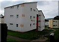
4
West side of Ashton House, St Dials, Cwmbran
Three-storey block of Bron Afon housing association flats viewed across Greenmeadow Way.
Image: © Jaggery
Taken: 20 Oct 2016
0.07 miles
5
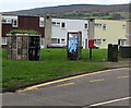
Street furniture near a Greenmeadow Way bus stop, St Dials, Cwmbran
From left to right are an eco-friendly wheelie bin shelter, http://www.geograph.org.uk/photo/5166788
BT phonebox, Queen Elizabeth II postbox and two telecoms cabinets.
Image: © Jaggery
Taken: 20 Oct 2016
0.07 miles
6
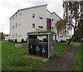
Green roof wheelie bin shelter in front of Ashton House, St Dials, Cwmbran
Located here. http://www.geograph.org.uk/photo/5166764 The green roof is planted with a variety of nectar-providing plants, such as marjoram, wild thyme, oxeye daisy and small scabious. These plants support pollinating insects such as bees, moths, butterflies and hoverflies. The shelter walls contain habitat for invertebrates such as the native solitary bee.
Image: © Jaggery
Taken: 20 Oct 2016
0.08 miles
7
Newchurch Court, St Dials, Cwmbran
Social housing owned by Bron Afon Housing Association.
Image: © Jaggery
Taken: 20 Oct 2016
0.08 miles
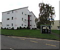
8
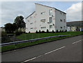
Ashton House, St Dials, Cwmbran
Bron Afon housing association flats viewed across Greenmeadow Way.
Image: © Jaggery
Taken: 20 Oct 2016
0.08 miles
9
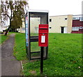
Queen Elizabeth II postbox and a BT phonebox, St Dials, Cwmbran
Located here http://www.geograph.org.uk/photo/5166798 at the edge of a Greenmeadow Way bus stop.
Image: © Jaggery
Taken: 20 Oct 2016
0.08 miles
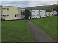
10
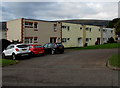
Row of houses in St Dials, Cwmbran
Set back from Greenmeadow Way in the St Dials area of Cwmbran.
Image: © Jaggery
Taken: 20 Oct 2016
0.08 miles