IMAGES TAKEN NEAR TO
St. Dials, CWMBRAN, NP44 4NL
Introduction
This page details the photographs taken nearby to NP44 4NL by members of the Geograph project.
The Geograph project started in 2005 with the aim of publishing, organising and preserving representative images for every square kilometre of Great Britain, Ireland and the Isle of Man.

There are currently over 7.5m images from over14,400 individuals and you can help contribute to the project by visiting https://www.geograph.org.uk
Image Map
Images are licensed for reuse under creativecommons.org/licenses/by-sa/2.0
Notes
- Clicking on the map will re-center to the selected point.
- The higher the marker number, the further away the image location is from the centre of the postcode.
Image Listing (91 Images Found)
Images are licensed for reuse under creativecommons.org/licenses/by-sa/2.0
Image
Details
Distance
1
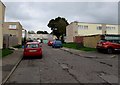
Marston Path, St Dials, Cwmbran
From Blenheim Road, Marston Path leads to Gileston Walk.
Image: © Jaggery
Taken: 20 Oct 2016
0.03 miles
2
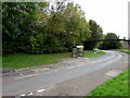
Blenheim Road bus stop and shelter, St Dials, Cwmbran
Below the Tamarind. http://www.geograph.org.uk/photo/5166883
Image: © Jaggery
Taken: 20 Oct 2016
0.04 miles
3
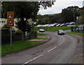
Warning signs facing Blenheim Road, St Dials, Cwmbran
On the approach to a bend in the road and a school.
Image: © Jaggery
Taken: 20 Oct 2016
0.04 miles
4
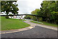
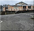
Footbridge over Blenheim Road, St Dials, Cwmbran
Viewed from the corner of the entrance road http://www.geograph.org.uk/photo/5324306 to Blenheim Road Community Primary School.
Image: © Jaggery
Taken: 20 Oct 2016
0.04 miles
5
Elan Walk, St Dials, Cwmbran
Viewed across Blenheim Road.
Image: © Jaggery
Taken: 20 Oct 2016
0.05 miles
6
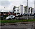
Tamarind, St Dials, Cwmbran
Viewed from Blenheim Road in April 2024. A board on the wall shows
"TAMARIND
RESTAURANT
& BAR
Contemporary Indian Cuisine
at its Finest"
Image: © Jaggery
Taken: 7 Apr 2024
0.06 miles
7
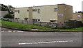
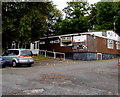
Power Station Community Education Centre, St Dials, Cwmbran
Torfaen County Borough Council building set back from Blenheim Road.
Image: © Jaggery
Taken: 20 Oct 2016
0.06 miles
8
Power Station Community Education Centre, St Dials, Cwmbran
Torfaen County Borough Council building set back from Blenheim Road.
Image: © Jaggery
Taken: 20 Oct 2016
0.06 miles
9
St Joseph's Social Club, Blenheim Road, St Dials, Cwmbran
The club's name sign shows the year 1965.
Image: © Jaggery
Taken: 20 Oct 2016
0.06 miles
10
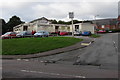
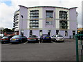
Tamarind restaurant and bar, St Dials, Cwmbran
Indian cuisine restaurant located in the former Marlborough pub above Blenheim Road.
Image: © Jaggery
Taken: 20 Oct 2016
0.06 miles